Holcomb Valley near Big Bear
On the eve of the American Civil War, the largest gold rush in Southern California was taking place in Holcomb Valley of the San Bernardino Mountains. Holcomb Valley is a mountain-top valley just north of Bear Valley where the popular resort of Big Bear Lake is located today. A trip into Holcomb Valley offers a great half or full day of exploring a forested area where you can still find slight traces of where over a thousand gold miners once dug for the elusive yellow rock.


Trip Specs
The History
But before you go, let us tell you a little history about the gold rush to Holcomb Valley which started in 1860, peaked in 1861, then continued to interest miners and investors off and on until the 1950’s. We’ll also explain a driving tour that will take you to some of the actual spots where different events took place during this gold rush. Although there aren’t any ghost towns to see, there are placer holes dug by the miners, some remains of ore mills and their tailings, an actual mining tunnel (adit) or two, old pieces of metal, and a few reconstructed cabins.
As with many other mining boomtowns of the 1800’s, there were lots of fanciful stories and legends told about them and sometimes those stories make it into today’s history books as “fact”. Oftentimes “history” is written based on the best knowledge available at the time (someone’s memory or best guess) only to be proven incorrect later on. With that in mind, we have written this article based on the “history” available to us.
Discovery
Bill Holcomb came out west from Indiana in 1850 to seek his fortune in northern California’s Mother Lode but he was not successful there. He began heading south, trying his luck in the Kern River and then at Newhall. He heard about prospectors who’d had a little luck in Bear Valley of the San Bernardino Mountains and so off he went. He was an excellent marksman and was hired by other prospectors in Bear Valley to hunt bear for meat. At that time, the San Bernardino’s were literally infested with giant California Grizzly Bear that maimed and killed prospectors on a regular basis. One day, while tracking a bear into the next valley to the north, Holcomb came across a ledge of quartz rock riddled with gold. Soon, the rush was on and the place was named Holcomb Valley.
Much of the gold mining in the early 1860’s focused in the center of Holcomb Valley. Of the three towns that emerged, the largest was Belleville which was named after the daughter of Jed Van Dusen. Van Dusen is also the name of the main road from the top of the old Brown Toll Road in the Cajon Pass to Holcomb and Bear Valleys and the name of a canyon in the area.
In 1860, there was a county-wide vote to determine where to place the county seat for the fast-growing area of San Bernardino and the town of San Bernardino won out over Belleville by just a couple of votes. Rumor has it that one ballot box from Belleville was mysteriously lost which would have certainly contained the votes needed to win the election.
A Rough & Tough Place
During the boom years of 1860 and 1861, Holcomb Valley was as wild and rough as any other western mining town. An estimated 50 murders took place in those two years. In August 1861, a bunch of bandits from Utah known as the Button’s Gang dominated Holcomb Valley. If they wanted to stay overnight somewhere, they would simply kick out the occupants or owners of a cabin and move in. They would also help themselves to any supplies they wanted. But, like many outlaws of the day, their lives came to a violent end. The Hangman’s Tree, a stop along the tour through Holcomb Valley, is where many outlaws met their maker.
Along with the bandits, most of the occupants of Holcomb Valley took sides in the developing Civil War. Tensions were high in the valley between Unionists and Secessionists. Miners that followed one gold rush to another had strong Southern sympathies. The Knights of the Golden Circle, a nationwide secret society that promoted separation from the U.S., held regular meetings north of Holcomb Valley (near Cushenburry Springs) to promote their cause. Miners that sided with the North congregated in northeastern Holcomb Valley which is still labeled Union Flat on maps today.
The big boom of Holcomb Valley ended after a strong blizzard struck the San Bernardino’s in January 1862. Mining continued in a more subdued fashion until about 1940 and there were a few “mini-rushes” during that time.
“Lucky” Baldwin and Gold Mountain
One was in 1874 when a gold discovery was made on Gold Mountain, near present-day Baldwin Lake. A famous mine developer, Elias Jackson “Lucky” Baldwin, invested in the site and the mini-rush was on. He spent a lot of money building a 40-stamp mill (which was huge in those days) in anticipation of all the gold that was to be mined. But just like with so many other rushes, the ore didn’t pay out as expected and Baldwin shut down his mill in less than a year. It mysteriously burned down two years later.
In 1900, Baldwin, along with a new investor, built a new 40-stamp mill just above the old one and excitement arose once more. The new operation kept going strong for three years, then after Baldwin’s death in 1909, the mine sputtered on with various owners until the dawn of World War II.
An Attempt at Dredging
In 1880, a British miner came to Holcomb Valley and began a dredging operation, which was becoming a popular mining method in California’s Gold Country. Somehow, the Brit estimated that there was $240 million in gold locked up in the soils of Holcomb Valley! Although it is unclear just how much gold was actually mined since 1860, it is unlikely that it ever reached more than a million. The Brit invested in a lot of equipment, had a labor force of 100 miners and brought up a steam shovel dredge to begin digging trenches. Operations started in 1891 and by 1895, an impressive trench measuring 3,000 foot (0.56 mile) long, 16 feet wide and 8 feet deep was dug. It is still visible in western Holcomb Valley. Not much gold was recovered and many investors in England lost a lot of money in the operation.
More…
Pictures
Below are some pictures of what you will see along the way.


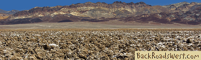
The sagebrush covered floor of Holcomb Valley
Virtual Video Tour on YouTube

Rock Climbing, Mountain Biking & Prospecting
Along with exploring and seeing historical sites, Holcomb Valley is also a great place to engage in rock climbing, exploring the many flat dirt trails on mountain bike and even gold prospecting
Even if you’re not into rock climbing, on a non-winter weekend, you will most likely find rock climbers near Holcomb Valley Pinnacles. They are certainly fun to watch. This climbing area is located just north of the town site of Belleville. To access this rocky area, go back to where our tour turns left onto road 3N05 off of 3N16. Just a short distance west of this junction, another road leads north labeled 3N07. You may have seen the sign pointing to Wilbur’s Grave and Arctic Canyon. Head north on this road until you hit the base of the hills, then bear right. All the granite outcroppings on the left (north) is great climbing material. This is also the source of much of the surface gold that washed down and was found in Holcomb Valley.
Because there are so many well-maintained roads in Holcomb Valley that are mostly on flat terrain, it is a great place to explore on mountain bike. We’ve driven to the center of Holcomb Valley, parked at one of the campgrounds or picnic spots, then unloaded our mountain bikes and spent a good portion of the day just looking around. Since there is very little traffic on the roads, it makes it especially nice. However, keep your ears tuned for vehicles and motorcycles as they won’t see you coming through the trees.
Although there are no more “professional” gold miners in Holcomb Valley today, there are still a number of gold prospector hobbyists that can be spotted. A number of gold prospector clubs have claims around the valley where you might find groups of people either panning or using a dry washer to find small particles of gold.
Vehicle Requirements
During most of the year, the dirt roads in Holcomb Valley can easily be accessed by most vehicles. However, there are times and situations where 2WD & AWD, or vehicles with low clearance, would not be adequate for these roads. This section explains some of those situations.
Naturally, the best vehicle to take on these roads is a high clearance 4WD vehicle. In most cases, high clearance 2WD trucks and SUVs are also suitable. The only exception where these vehicles would have difficulties is during the winter snows or when there is a lot of mud during snowmelt.
Keep in mind that the length of this trip is 12.5 miles, which is entirely on dirt roads. 2WD & AWD vehicles are built for street use and are not equipped with extra suspension and protection from bumpy dirt roads with loose rocks. Using such vehicles on dirt roads could damage them or at least greatly add to their wear and tear, leading to premature aging of the vehicle.
Unlike improved paved roads built with drainage systems, dirt roads are subjected to water erosion from rainstorms throughout the year. This causes ruts and gullies that cut holes into the roads. Driving over these obstacles will sometimes be challenging, especially in vehicles with low clearance. Often, these gullies are not fixed by road crews for many months or years and become deeper after each rainstorm.
For 2WD & AWD vehicles, there are two potentially difficult sections of the route that are steep. One is the climb up Polique Canyon Road, however the grade is not too steep. The roughest section of the route is the descent near Gold Mountain. Vehicles with low ground clearance should not attempt this last section of the trip and not go further than the Metzger Mine (stop #11), unless it was reported that the road is in good condition.
These and others are all situations to consider when driving the roads in Holcomb Valley. Before traveling these roads, it is recommended to visit either the Big Bear Discovery Center or the Big Bear Ranger Station to inquire on the condition of the roads.

The Driving Route
A driving tour through Holcomb Valley can be a fun experience. There are plenty of places to get out and walk through the sites where much of the history mentioned above took place. You can either hit all of the sites in a random order or take a more systematic route. A blog post on our website explains a suggested route to visit the sites along with an interactive map that points them out. Also included is a virtual video tour showing the route with an animated map and how all the sites look as of 2016.
When you do plan your visit to Holcomb Valley, we strongly suggest stopping in at the Big Bear Discovery Center. They can provide you with a wealth of information about what to do and see in the Big Bear area. Also pick up a handy pamphlet called “the Gold Fever Trail” describing a self-guided auto tour through Holcomb Valley (which our own route follows).
Start at the Discovery Center
Our tour starts by heading north on Polique Canyon Road (2N09) from Hwy 38. This intersection is located 0.8 mile from the Discovery Center. At 3.2 miles from the Center, 2N09 reaches a summit and intersects the Pacific Crest Trail. Walk the trail east a short distance for a sweeping view of Holcomb Valley.
Continue down 2N09 into Holcomb Valley to the first stop at 4.8 miles. This is the site of many placer holes. Placer mining is a simple technique where miners simply dug into the flat ground and processed the dirt looking for gold. They processed it by panning, using a sluice or an arrastre. An arrastre still exists near the town site of Belleville.
Back on 2N09, make a right turn onto Holcomb Valley Road (3N16). At 5.4 miles, turn left onto road 3N05. This is a loop road that passes by several sites along the Gold Fever Trail. It T’s into 3N16, where you turn left. Just after turning left is the site where Bill Holcomb first discovered gold, staked a claim and began mining gold in 1860.
A short distance later is the town site of Belleville. Here you’ll find a reconstructed log cabin and the arrastre mentioned earlier. There is also a nice view of the meadow that covers a good portion of Holcomb Valley.
Continuing east on 3N16 will take you all the way back to Hwy 18, a distance of about 5.6 miles. Along the way, you’ll pass by more sites including two hard-rock mines, one of them being the Lucky “Baldwin” and the site of Bairdstown (Doble).
Trip Map
The yellow line marks our approximate route. Learn more about our maps.
Comments
Read and leave comments about this post on YouTube.
Support Us
Help us fill up our tank with gas for our next trip by donating $5 and we’ll bring you back more quality virtual tours of our trips!
Your credit card payment is safe and easy using PayPal. Click the [Donate] button to get started:
Subscribe
See all our comprehensive virtual tour guides at:
![]()