 |
"Knowledge for the western back roads explorer..." |
|
|
|
Map DataView our tours using on-line mapping software such as Google Earth.
As an added bonus to our Virtual Tour Guides, map data files are available for some of our trips. These map data files can then be viewed using popular map viewing software such as Google Earth or ESRI's ArcGIS Explorer which can be used for free on the Internet. These map data files are programmed in what is known as KML. KML stands for Keyhole Markup Language and is a programming technology standard owned by Google. KML uses the XML data formatting standard. If you open a KML file with a word processor or editor, you will clearly see the individual points, known as "placemarks", along the trip. Available SoftwareThere are several map viewer software products available for free on the Internet that will view KML files. Google Earth is by far the most popular. Although Google Earth is typically a program that you install on your computer, there is also a "web plug-in" available so that the same functionality can be accessed from your web browser. ESRI and Microsoft also have free offerings available. When planning our trips, we use both Google Earth and ArcGIS Explorer. This is simply because each program has its own pluses and minuses. We "pre-run" most of our trips with these programs to make sure we are not missing anything before we physically go out and take our trip. Google Earth
Google Earth has become a very popular program that is in use throughout the world. Many other companies are now using Google Earth to display their own information. It is easy to operate and only requires a typical personal computer to operate on. It also needs a live Internet connection to access the imagery. Find out more by going to Google's website and search for "Google Earth". From there, you can download and install the program on your computer and read instructions on how to use it. ArcGIS Explorer from ESRI
There are pluses and minuses to using ArcGIS Explorer. Here are the pluses:
Here are the minuses:
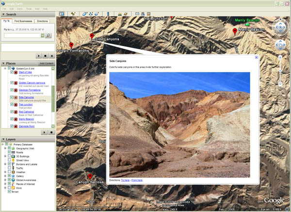
Map Data AvailableCurrently, we have a few different map datasets available in support of our two guides for Death Valley and the Mojave National Preserve. Not all chapters and trips in our guides are covered in our collection of KML map data. After you click on any of the links below, your computer should prompt and ask if you wish to open them with Google Earth (or which ever program is registered to open KML files on your computer). This will not occur if you do not have Google Earth installed. The globe should then zoom into the general area that the KML file is showcasing. The KML file plots a series of red-colored balloons on the imagery or map. Click on any of the red balloons to view a small explanation and picture(s) about that particular point in the tour. Google Earth and ArcGIS Explorer both have a "Play Tour" feature which steps through each red balloon in the KML file. Both programs also display each of its points in the KML file in an index on the left side of the program. You may also click on on this index list to reveal or view each tour point.
Sample screen of Google Earth. Notice the red balloons on map and the index at left. Clicking on any of the red balloons (either map or index) will display a larger balloon with description and picture (as seen in this example). Before clicking on any of the hyperlinks below, you must have either Google Earth or ArcGIS Explorer installed on your computer. Otherwise, your computer will not know what to do with the KML files. Death Valley Area
Mojave National Preserve
Your FeedbackFeel free to contact us if you have any feedback on our KML files. Since this is a new experiment for us (February 2009), we are curious on how other people use programs such as Google Earth. Click here to send us an e-mail. |
 This program is downloaded off the Internet and installed on your
computer. Once it is on your computer, you can use it to view aerial
or satellite imagery of just about anywhere on the Earth. Along with
the imagery, it also shows where roads are located, places of interest
such as cities and points of interest and boundaries. One unique
feature of Google Earth is that you can see the Earth's terrain in three
dimensions and it allows you to "fly around" over the terrain as if you are
in an airplane.
This program is downloaded off the Internet and installed on your
computer. Once it is on your computer, you can use it to view aerial
or satellite imagery of just about anywhere on the Earth. Along with
the imagery, it also shows where roads are located, places of interest
such as cities and points of interest and boundaries. One unique
feature of Google Earth is that you can see the Earth's terrain in three
dimensions and it allows you to "fly around" over the terrain as if you are
in an airplane. ESRI is one of the leading manufacturers of mapping software in the
United States. They also have a program similar to Google Earth called
ArcGIS Explorer that is available for free. See the
ESRI is one of the leading manufacturers of mapping software in the
United States. They also have a program similar to Google Earth called
ArcGIS Explorer that is available for free. See the
Back to Home