Route 66 through the Cajon Pass
Before Route 66 reaches the Pacific Ocean in Santa Monica, it has one last obstacle to negotiate – the Cajon Pass. Other than a small mountain pass east of Albuquerque and the high summits near Flagstaff, the Cajon Pass is the most significant mountain pass along the entire length of Route 66.
Our virtual video tour will show the alignment that Route 66 followed through the Cajon Pass from north to south since its inception in 1926. Unfortunately, when I-15 was built in the late 1960s, the northern half of the old alignment was either erased or I-15 was built on top of it. Our tour will show some old pictures and compare them to current-day pictures of the same area to give you a sense of where these old alignments used to exist. You’ll also see the southern half of the Cajon Pass where much of the alignment is still drivable today.
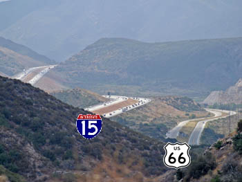

Although there doesn’t seem to be much to see in the Cajon Pass, there actually is quite a bit. Whether you enjoy history, a train buff, looking at geology or you’re a Route 66 fan, the Cajon Pass has a lot to offer. Today, the pass is traversed by a lot of roads, making for easy access.
History
The Cajon Pass has a long history when it comes to transportation. For travelers and pioneers of the 1800s coming from the east, there were only three ways to enter that ever growing and popular region that we now know as the Greater Los Angeles Area. The northern half of the L.A. Area is surrounded by the 10,000 foot (3,000 m) high San Gabriel and San Bernardino Mountains. There is only one significant opening through this barrier – the Cajon Pass.
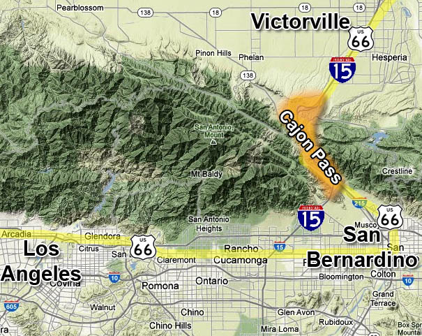
Location of the Cajon Pass
Settlers coming into the area began using the Cajon beginning around 1830. The first two long-distance roads or trails that passed through the pass were the Old Spanish Trail and the Mormon Road. The Old Spanish Trail, which originated in Santa Fe, New Mexico, was established first. The Mormon Road, established in the 1840s, originated in Salt Lake City. Both roads used near-identical alignments through the Cajon.
Traffic through the Cajon began to increase in the 1850s. In 1861, an entrepreneur named John Brown built a wagon toll road through the Cajon Pass which would influence later roads through the Cajon. Read more about this part of Cajon history on our Forgotten Path of Route 66 tour.
Santa Fe Railroad (AT&SF – now BNSF) built the first railroad through the Cajon Pass in the early 1880s. Over the decades, additional railroad lines were built; the last one was just built in 2005. It would be the AT&SF line, from Chicago to Los Angeles, that Route 66 would eventually follow.
The first automobile route through the Cajon was established in 1914. In 1926, along with other route numbers U.S. 91 and 395, it was designated U.S. 66. In 1930, the alignment through the northern half of the pass was modified by digging large road cuts, which was quite a feat in those days. The two lane road was upgraded to four lanes (two lanes in each direction) in 1950. Finally, with the age of Interstate highways, the eight lane I-15 freeway was built around 1967.
Most of the old four lane portion of Route 66 was erased in the northern half of the pass as the new freeway was built on top of it. However, most of the four lane portion is still intact and drivable in the southern half of the pass.
Northern Half of the Cajon
As mentioned, most of Route 66’s old alignment was erased when I-15 was built. This fact continues north from the Cajon Summit and into Victorville. It isn’t until the Palmdale Road exit in Victorville where the old alignment of 66 can be found as it follows 7th Street into downtown.
As you’ll see in the virtual tour, small portions of the two-lane Route 66 can be seen at the summit between the southbound and northbound lanes of I-15. It is now a service road that leads to several radio towers. After the towers, the road was completely obliterated when the larger road cuts were dug for I-15’s southbound lanes.
Traces of the old alignment can faintly be seen along the right side of I-15’s southbound lanes as it makes its large sweeping turn to the south before the runaway truck ramp. Route 66’s alignment took a much longer sweep or arc then I-15 and then snaked back again to take advantage of an even gentler sloop then what I-15 uses today. Pictures on the virtual tour point out the old alignment.
Just north of where the north and southbound lanes of I-15 rejoin near the runaway truck ramp is where the old road crossed and headed toward the first (most northern) railroad bridge. The dirt road that goes beneath the three railroad bridges was where Route 66’s alignment used to be. See the historical picture of one of the bridges in the virtual tour.
Accessing the northern half of the Cajon Pass to find these old alignments requires a 4WD or high-clearance vehicle. The easiest way to access the area is from the S.R. 138 and I-15 intersection. From S.R. 138, just to the right of the northbound I-15 on-ramp, there is a dirt road. Take this road heading north. It will parallel I-15 and pass underneath the aforementioned railroad bridges. At this point, the dirt road sits on top of the old Route 66 roadbed. Continue heading north and the road will then pass underneath both sets of lanes of I-15. A few hundred feet beyond the second set of lanes is where you can find the old pavement of Route 66, but it is hard to locate because it is hidden in thick brush. If you plan on driving this dirt road, be aware that it is popular with dirt bikes so be prepared to encounter fast moving small motorcycles.
Scroll-Comparison: Then & Now of Gish Underpass
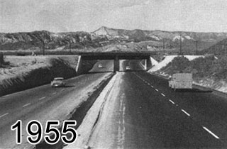
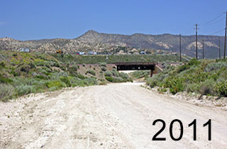
Click and move mouse back and forth to see a 1955 to 2011 comparison of the Gish Underpass, which is the first railroad bridge north along I-15 from S.R. 138.
Highway 138 Intersection
The intersection of I-15 and S.R. 138 roughly marks the halfway point through the Cajon Pass. Here is where you can begin driving sections of the old Route 66 alignment.
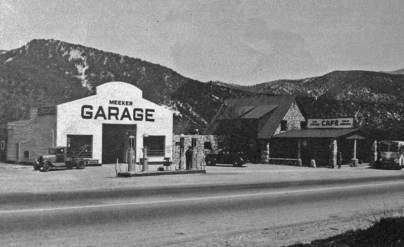
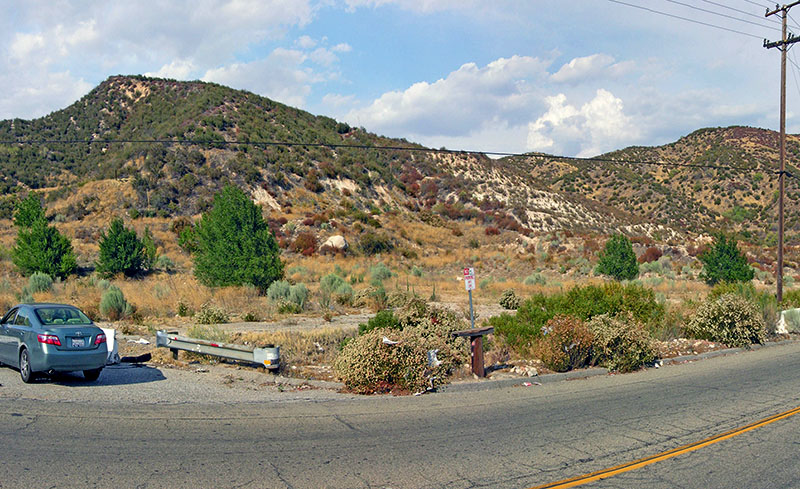
On S.R. 138 just east of I-15 is a road named Wagon Train Road that parallels I-15 and leads south to a McDonalds and a gas station. This road was the two-lane alignment of Route 66. Across the street from the gas station is where several businesses that used to service Route 66 travelers starting in the 1930s. The last building, a cafe, was razed in the late 1990s.
At the end of this road is a monument to several old wagon roads that passed by here, plus the alignment of the first automobile route exits a narrow canyon. Here, Route 66 roughly crossed where I-15 sits now and connects with roads that still exist on the other side.
Below is another comparison between the site of the Meeker Garage (across the street from the gas station) as it looked in 2012.
Scroll-Comparison: Then & Now of Meeker Garage
Shop for Route 66 items
Scroll down to see and shop for items related to Route 66 from Amazon.
Books Recommended on Amazon
Virtual Tour on YouTube
Southern Half of Cajon Pass
To drive the southern half of the Cajon Pass on the original alignment of Route 66, enter southbound I-15 from S.R. 138 and take the next exit named Cleghorn Road. You’ll see the sign pointing the way to Historic Route 66. Turn right at the end of the off-ramp.
The road begins to parallel the railroad tracks. A short distance later, the road crosses a bridge with an old cement guardrail. The year 1930 is stamped on the side.
As the road slowly sweeps to the left and climbs, several older alignments of Route 66 used to go off to the right. Because these older alignments were closer to Cajon Wash, they were washed away during various floods when the waters swelled during storms. In 1952 when the divided highway was built, it was realigned higher on the hill to avoid further washouts.
When the road turns right, crests and begins to go downhill, you’ll start seeing the eroded northbound lanes of the highway which is closed to traffic. The road you are driving on is the old southbound lanes. If you wish, you can carefully cross over to the northbound lanes to see where Route 66 shields were first painted on the pavement. There are also two parallel bridges nearby that has different years stamped on each bridge.
Signs marking Route 66 used to be commonplace when it became popular once again to travel the old Mother Road. Sadly however, those signs were constantly being stolen. The road maintenance department of San Bernardino County began experimenting with another way to mark the old road by painting the highway shield on the pavement. Nobody could steel that. On the old northbound lanes here, the road department experimented with different designs and finally picked one. Now, you can see painted high shields all along the old highway and other road departments along the highway’s entire route are now using the same idea.
Blue Cut
About 2.5 miles from the off-ramp, Route 66 makes a large turn to the right (west) following Cajon Wash. The wide area you’ll see on the right side of the road is the old Blue Cut rest area that was built when the divided highway was built.
In the 1930s, this was also the spot where authorities stopped refugees from the Dustbowl regions of the mid-west that were looking for a better life in California. Refugees were kept here for a few days to a few weeks while authorities did background checks on the refugees.
Blue Cut got its name from the bluish tint on the rugged hillside across from the Blue Cut rest area. This is the spot where the mighty San Andreas Fault slices through the Cajon. It was the San Andreas that actually created the Cajon Pass in the first place. Standing at Blue Cut, if you look northwest across Cajon Wash and the railroad tracks, you’ll notice a long and straight narrow valley. This is the path of the fault, with the actual “crack” located halfway in the middle of the valley. A small lake, named Lost Lake, which was created by the fault, is located roughly a mile up the valley from Blue Cut.
When you pass by here, you may see several parked cars here or people walking around. This area is popular with train buffs for watching the trains go by. It is also a popular with a certain group of people that like to meet each other. Be careful if you are approached by anybody in this area if you get out of your vehicle.
Just beyond Blue Cut you’ll see a classic stone wall along the road. This wall was built in the 1930s. After that, the road snakes through the narrowest part of the Cajon Pass.
Mouth of Cajon Pass & Devore
Past the stone wall, Route 66 passes through the narrowest part of the Cajon. It then makes a sweeping left turn to the southeast that ends with a long straightaway. Here you can enjoy seeing long stretches of the old divided highway.
At 6.3 miles, this portion of Highway 66 ends and you have to turn left to return to I-15 on Kenwood Avenue. Just before turning left on Kenwood however, if you look straight (in the continued direction of old 66), you will see how much the old divided highway eroded away since it has no longer been used when I-15 was completed in 1968. However, as of 2014, this section of Route 66 is being modified along with the I-15 and I-215 freeway intersection and will result in a historic reconnection of Route 66.
To continue your journey on 66, enter I-15 southbound at Kenwood Ave. Immediately, transition into the left lanes and continue straight on I-215 towards San Bernardino. Then, take the next exit, which is signed Devore (see our virtual tour for an animated map). When you get to the end of the off-ramp, turn right. Be aware that if you are reading this after 2015, the freeway intersection has been rebuilt.
Now, you’re back on old 66. The distance from the off-ramp to the end of the road is just a few hundred feet. The old road was chopped off by the more modern freeways. On the left, you’ll see a couple of diners that used to exist on the old road. Beyond the end of the road, you can see the old pavement of the divided highway that met up with the portion you saw when you turned left on Kenwood Avenue.
Behind the diners is an older alignment of Route 66 before the divided highway was constructed in the 1950s. You can drive on this old alignment by going back towards the off-ramp and then make a hard right turn just after the fire station. Here, you will find a small service road to some towers. This was the pre-1950s alignment of 66. See the virtual tour for aerial images of this area showing where the old alignments are located.
Continue your journey by driving past the four-way stop southeast on Route 66, which is now named Cajon Blvd. The original 1950 version of Route 66 along this section was an undivided four-lane highway. By around 1960, modern-day I-215 was built and Route 66 traffic used this instead. After 1.2 miles, the four lanes are reduced to two lanes and the old road passes underneath the railroad tracks.
It was underneath this bridge where, in November 1954, entertainer Sammy Davis Jr. seriously crashed his car on a return trip from Las Vegas. He almost lost his life and it resulted in the loss of one of his eyes.
At this point, Route 66 is out of the Cajon Pass and now in the San Bernardino Valley. The road continues southeast for another 8.5 miles to downtown San Bernardino. Here, Route 66 turns right and heads due west on first, 5th Street, and then Foothill Blvd. It stays on Foothill Blvd as it enters the Los Angeles area and then switches to other roads near Pasadena. It continues switching to other roads through the heart of Los Angeles until its end in Santa Monica.
Epilogue
This article covers just a fraction of the things to see and know about when you go visit Route 66 through the Cajon Pass. There are many more pieces of history that make up the complete story about Route 66 that is difficult to fit into this article. Use your favorite Internet search engine to search for more information regarding Route 66 and the Cajon Pass, or buy one of the books listed above the Virtual Tour.
Trip Map
Support Us
Help us fill up our tank with gas for our next trip by donating $5 and we’ll bring you back more quality virtual tours of our trips!
Your credit card payment is safe and easy using PayPal. Click the [Donate] button to get started: