Pilot Rock Road
2N33 aka Pilot Rock Road, Riding High Over Silverwood Lake:
Where the Mojave Desert meets the San Bernardino Mountains, there are a number of unknown back roads where you can enjoy the transition from the desert vegetation to the mountain shrubbery. One such road is seldom used and offers great scenery while transitioning from desert to mountain habitats in a short distance. This trip is also great for escaping from hot summer days.

Our road trip starts out in the rural landscape of Summit Valley, just south of Hesperia, and takes us on a dirt road that wanders along a high mountain ridge overlooking Silverwood Lake and then eventually takes us into the pine trees of Lake Arrowhead. It won’t be too long into this trip that you’ll start smelling the fresh, cool mountain air. And, along with the cool air, you’ll see some outstanding views of the desert and the mountains.
Virtual Video Tour on YouTube

Getting There
Start this trip by getting to Cedar Springs Dam at Silverwood Lake. One way to get there is to take Main Street in Hesperia to its eastern end. When Main turns into Arrowhead Lake Road, reset your odometer to zero. Continue for 5.7 miles and turn right onto Hwy 173 after crossing a dam. At the 10.5 mile mark, turn left onto the paved road leading to Cedar Springs Dam. If you’re coming from the I-15, exit at Hwy 138, reset your odometer to zero and follow the signs to Silverwood Lake (east). At 8.3 miles, turn left onto Hwy 173. Just after passing the dam, turn right onto a paved road at the 10.5 mile mark.
This paved road will take you to an overlook of Cedar Springs Dam. Just before the overlook’s parking lot, a dirt road leads off to the left. This is Forestry Road 2N33 and will be the start of our road trip. When you’re ready, reset your odometer and start up 2N33.
Pilot Rock Road is located inside the San Bernardino National Forest. If you plan on parking your vehicle for an extended period of time, such as for a hike that will last a few hours, the National Forest Service requires vehicles to display an Adventure Pass.
Road Trip
Forestry Road 2N33 (also known as Pilot Rock Road) is the dirt road that is showcased on this trip and the entire length is 11.5 miles. This is a great road for your truck or SUV with 2WD so long as it hasn’t rained or snowed recently. If it has, the road may be muddy and have deep ruts, requiring both high clearance and 4WD. During the winter months, many sections of the road are in the shade causing the road to be iced over. During such conditions, you definitely want to travel 2N33 with 4WD.
Starting out at 3,500 feet, 2N33 climbs gradually to an elevation of 5,000 feet. For the first 3.5 miles, it hugs the side of a ridge as it winds around Silverwood Lake. Then the road turns due east and rides on top of a mountain ridge for almost the rest of the way. While 2N33 is on this ridge, you will enjoy outstanding views in all directions.
At 2.7 miles, a rough spot in the road may be encountered. Here, you’ll find a water tank used for flood control on the left side of the road. Often, water from this tank flows out onto the road, which creates deep ruts. This typically occurs after long periods of rain or snow. If you don’t have a high-clearance vehicle with 4WD, you might wish to consider driving this road well after such weather has occurred.
Another obstacle to be aware of is ice. As 2N33 passes on the north side of the ridge or under the shade of trees, if it has been cold over the past week, ice will develop on the road. If the ice is extensive enough, it will be difficult for most vehicles to cross it.
View Point
The best viewpoint along 2N33 is at the 3.5 mile mark. Here, you will have a sweeping view of the entire expanse of Silverwood Lake. There is a large pullout here where you can park and enjoy the view. Once, when we were here on a very clear day, we were able to see the snow-topped Sierra Nevada Mountains 120 miles to the north. For High Desert dwellers, it’s usually clear enough to pick out your own neighborhood. You may wish to pack a pair of binoculars to use at this viewpoint so that you can find the various faraway landmarks.
About Silverwood Lake
Silverwood’s purpose is to store water for the California Aqueduct. The setup of the reservoir is actually in reverse as compared to normal dam/ reservoir setups. With normal reservoirs, water from rivers enters in from behind, with the dam located at the front of the reservoir, where the water leaving the reservoir is regulated by the dam. In Silverwood’s case, water from the aqueduct enters the lake next to the dam. Water then exits the lake at the lake’s rear, near the marina. Here, the water enters a long tunnel and exits near Cal State University San Bernardino, which can easily be seen from the I-215 Freeway, as the water continues to points south. So in that regard, Silverwood Lake is unique – it’s a backwards reservoir.
Pictures
Below are some pictures of what you will see along the way.


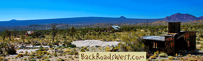
Panoramic view of Silverwood Lake from Pilot Rock Road
The Ridge
Continuing on 2N33, the road occasionally switches back and forth on each side of the ridge, conveniently giving you a change of scenery. Along this stretch, you’ll see a second road running parallel to 2N33. It is quite eroded and climbs and descends steeply. This road is meant for motorcycles. You’ll want to stay on the more flat 2N33.
At the 6 mile mark, 2N33 intersects with a road that descends the ridge steeply to the south. This is 2N36. It goes down to Miller Canyon, which is directly below the ridge. This road leads to the pavement of Hwy 138. Our trip continues east on 2N33.
Pilot Rock
At 8 miles, Pilot Rock comes into view, with a parking area to hike to it 0.4 miles further. Pilot Rock most likely got its name from being used by surveyors and early airplane pilots as a fixed point of reference.
At this point, you may have noticed all of the large bushes with deep red or burgundy colored bark. This is the Manzanita bush and you’ll find two different species here. One has a very green leaf, while the other has a bluish-green colored leaf. The green-leafed species is the one that brandishes the beautiful red bark. Take some time to look at these beautiful bushes and notice all the different shapes and designs of its bark or watch our accompanying YouTube video that virtually shows this road trip along with several examples of this magnificent plant.
During one visit, we climbed to the top of Pilot Rock. It takes quite a bit of rock-climbing skill. Once you get to the top, it is an outstanding view. On the top of the rock, someone carved a most profane statement. We won’t tell you until you reach the top.
Oh, okay, for those that don’t want to risk the precarious climb, we’ll tell you. As you are looking at that outstanding view, think about how great the view is. Then, look down. You’ll see the carving of that profane statement. It says, “I know”.
Saddle Flats
Soon after Pilot Rock, 2N33 leaves the ridge and enters Saddle Flats. You will no longer see views of the desert. The terrain now looks like you are in the mountains as you are surrounded by pine and other trees. This is fairly flat place to enjoy some mountain biking. There are also a few hiking trails scattered around. One such trail has a parking area for it which is located where 2N33 Ts into Hwy 173.
Just after descending a small canyon and crossing a creek, which is Grass Valley Creek, 2N33 ends at a stop sign along Hwy 173. Turning left here will now take you to a dead end. Before 2010 however, Hwy 173 used to continue on a windy path down a canyon and back to Hesperia. This section of 173 is dirt and was the only state highway comprised of a dirt road in the entire State of California. Caltrans closed this section of Hwy 173 permanently when there was no funding available to widen and pave the road. See Wikipedia article on Hwy 173.
Turning right at the stop sign will take you into Lake Arrowhead. Consult a map or GPS to find the various tricky routes to Arrowhead Village and Blue Jay. We usually follow 173 south for a mile, turn right onto Grass Valley Road, continue for 4 miles, then turn left on Hwy 189, and 189 will take you into Blue Jay and Arrowhead Village. There are plenty of great places to eat and enjoy once you’ve made your adventurous journey along 2N33.
Trip Map
To help plan your trip, either use our interactive Google Map below or download our GPX file that points out the places to see that are mentioned in this chapter.
Click here to download our GPX file for the Pilot Rock Road (2N33). We recommend using a GPS mapping app, such as Gaia GPS, to view these points on your computer or to locate them using GPS with your mobile device or phone. Click the ad below to purchase Gaia GPS using our discount code which offers up to a 50% discount.

The yellow line marks the approximate route.
Learn more about our maps.
2N33 starts near the lookout to Cedar Springs Dam
Located here is the sweeping view of Silverwood Lake and the desert to the north.
2N33 leaves the ridge and enters Saddle Flats.The number of pine trees increase.
Pilot Rock Road intersects with Hwy 173.
Support Us
Help us fill up our tank with gas for our next trip by donating $5 and we’ll bring you back more quality virtual tours of our trips!
Your credit card payment is safe and easy using PayPal. Click the [Donate] button to get started:
Subscribe
See all our comprehensive virtual tour guides at:
![]()