Burr Trail Utah
The Burr Trail is yet another wonderful back road through the scenic red rock country of Southern Utah. Burr Trail stretches 68 miles from the small town of Boulder, Utah, located along Hwy 12, to Bullfrog located on the shores of Lake Powell. Along the way, Burr Trail passes through Grand Staircase Escalante National Monument and Capital Reef National Park.


Trip Specs
Length
Attractions
- Many scenic geologic features
- Slot Canyons – Long Canyon
- Views of Capital Reef
- Classic switchbacks
- Access to other areas
Difficulty
- Half of trip is on pavement
- Other half on well-maintained dirt
- Sharp 180° turns on switchbacks
- Remote area – phones will not work
Elevation Gain
- 6,700 feet at Boulder
- 3,700 feet at Bullfrog/Lake Powell
- 3,000 feet total difference
Originally developed by a rancher named John Atlantic Burr to move his cattle between summer and winter grazing grounds, the Burr Trail is now one of those classic Utah “backways” that the State frequently advertises. The road passes through a wide range of Utah scenery, beginning on the west side with red sandstone cliffs, passes through the Waterpocket Fold of Capital Reef National Park and ends on its eastern end with the serene beauty of Lake Powell. One of the engineering feats that Burr undertook is the amazing switchbacks that the road uses when it crosses the Waterpocket Fold.
Getting There
The Burr Trail can be reached from three places. You can begin your trip on its western end at the town of Boulder, from Captial Reef National Park in the north or from Bullfrog, which could be included with a unique ferry trip across Lake Powell. It just depends on what other destinations you have planned on your overall trip through Utah.
Its western end can be reached from Utah’s beautifully scenic Highway 12. This intersection is located just on the south end of Boulder about 27 miles east of the town of Escalante.
Its eastern end is located at the town of Bullfrog. This can be accessed either from Highway 276 or by using the ferry that crosses Lake Powell and comes from the town of Blanding.
In the middle of the Burr Trail, 36 miles east of Boulder, the spectacular geological feature named the Waterpocket Fold is crossed. On the east side of this feature, a road to the north gives access to the main part of Capital Reef National Park.
We’ve traveled on the Burr Trail three times, each time approaching it from different angles. Once, we simply drove in from Boulder, drove the 36 miles to the Waterpocket Fold and the Strike Valley Overlook, then returned back to Boulder. Another time, we started in Blanding, double checked the ferry times across Lake Powell (they don’t run very often), and enjoyed the 30 minute cruise across the lake.
WARNING: If you plan on driving Burr Trail all the way to Bullfrog and Lake Powell, be aware that if the lake is at “full pool”, it submerges a section of Burr Trail at about 60 miles from Boulder, making it impassable. Inquire locally to learn if the road is open to Bullfrog. Places to check include the BLM visitors center in Escalante or the Anasazi State Park Museum in Boulder. Also, if you plan on using the ferry to cross Lake Powell, also inquire if the ferry is running. It is frequently broken and doesn’t operate for several days.
More…
Support Us
Help us fill up our tank with gas for our next trip by donating $5 and we’ll bring you back more quality virtual tours of our trips!
Your credit card payment is safe and easy using PayPal. Click the [Donate] button to get started:
Pictures
Below are some pictures of what you will see along the way.


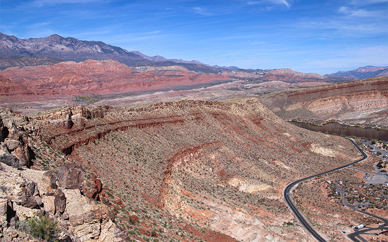
View looking east just before crossing the Waterpocket Fold

The Road
Starting from the western end at Boulder, the Burr Trail starts out as a fairly good paved road with no center stripe. It quickly enters Grand Staircase Escalante National Monument and passes by a campground. At 9.5 miles in, it makes a dramatic drop into Long Canyon. Burr Trail continues inside the deep and amazing Long Canyon for several miles as it passes by some geologic features.
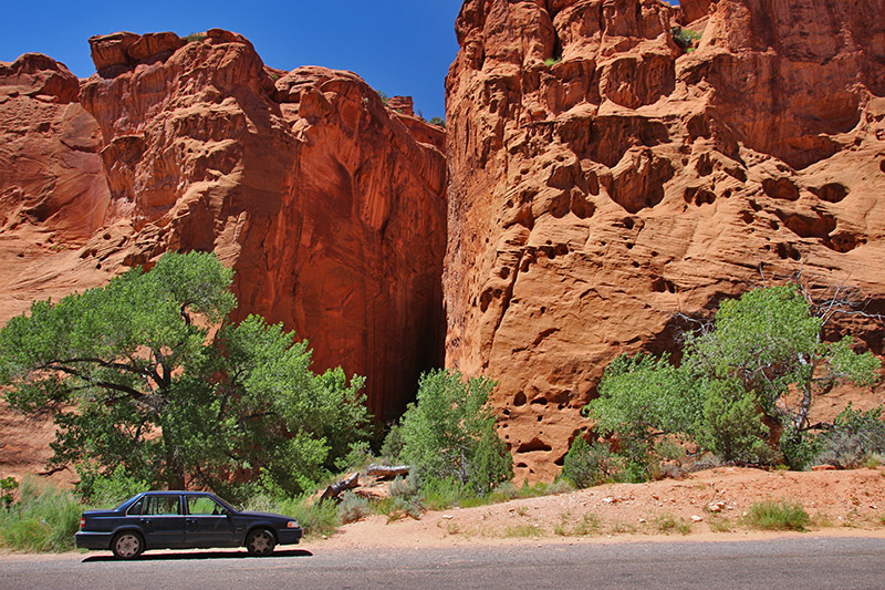
The first of those geologic features to see is a short but deep slot canyon located just off the road on the left at 11.4 miles. Supposedly, this canyon is called Singing Canyon by the locals because of its outstanding acoustical properties. So when you visit, hopefully a famous opera star will also be visiting to demonstrate the acoustics!
Park on the side of the road and find one of the several trails that lead to the canyon. One or two large cottonwood trees protect its entrance and my hinder the opening to the canyon. This is worth the stop to take the short walk into the canyon, even for people that are claustrophobic.
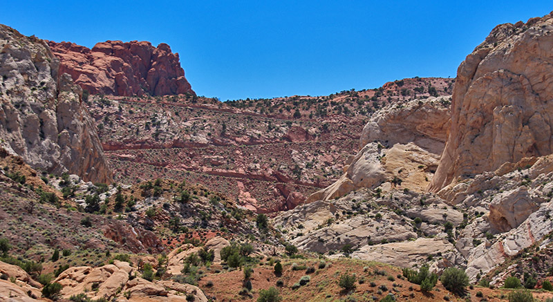
The road climbs out of Long Canyon at 17.5 miles and heads east toward Capital Reef. At 30 miles, the pavement ends and the Burr Trail enters Capital Reef National Park. For the remainder of the trip to Highway 276, the road is dirt but is usually passable for automobiles. However, if there has recently been wet weather, the road will be muddy and impassable for 2WD autos and difficult for 4WD vehicles.
At about 32 miles, a road goes to the left that is signed Upper Muley Twist Canyon. This road is only passable for 4WD vehicles and leads to a breathtaking panoramic view of Capital Reef’s Waterpocket Fold. Unless you were flying in an airplane, the only way to get a good view of this huge geologic feature is by hiking the short trail to an overlook located at the end of this road. This is known and signed as the Strike Valley Overlook.
Back on Burr Trail heading east, you will soon descend the famous switchbacks that is one of the highlights of this journey. The road descends 1,000 feet in less than a mile. This marks the eastern face of the Waterpocket Fold.
At the bottom of the switchbacks, which will be 35.8 miles from Boulder, you will run into a T intersection and the Burr Trail turns right (south). It follows the bottom of the Waterpocket Fold for the remaining distance to Bullfrog. Here, the road passes through very colorful low-laying hills along with the dramatic Waterpocket Fold on the right side. At 46.7 miles, turn right to continue on Burr Trail and you will be rewarded with pavement once again.
If Lake Powell is at “full pool”, Burr Trail might be submerged at about 60 miles from Boulder. As mentioned previously, inquire locally to confirm if the road is open at this point. Also inquire if the ferry is operating.
Trip Map
Learn more about our maps.
Support Us
Help us fill up our tank with gas for our next trip by donating $5 and we’ll bring you back more quality virtual tours of our trips!
Your credit card payment is safe and easy using PayPal. Click the [Donate] button to get started:
Subscribe
See all our comprehensive virtual tour guides at:
![]()