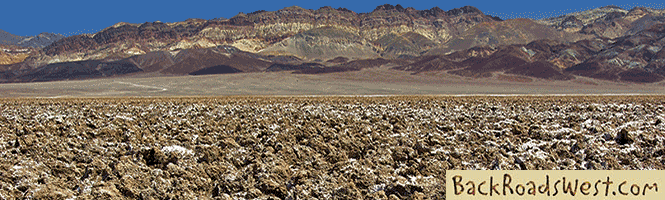
Cactus Flats near Big Bear
Cactus Flats is an area in the San Bernardino Mountains just east of Big Bear Lake that lives up to its name – it’s a flat area full of cactus. The cactus they refer to, however, is not really a cactus at all. It is the iconic Joshua tree which is, technically, a member of the yucca family and not a cactus or a tree. But whatever you call it, it is a unique and majestic symbol of the Mojave Desert region and they are abundant on this trip.


Trip Specs
Our Trip
This road trip through Cactus Flats starts off of Highway 18 halfway between Lucerne Valley and Big Bear. You’ll need a high-clearance vehicle and possibly 4WD as we wind through rugged mountain scenery, areas of thriving Joshua trees, past an old mining area, through a very remote residential area, and then end up near historic Pioneertown near the city of Yucca Valley. Plan to spend an entire day taking this road trip.
Although this journey may not be as scenic or historic as some of the other trips we’ve taken you on, it does offer something that many people (like us) seek out – peace and quiet with no crowds. You’re likely to have the roads all to yourself which makes it a nice day out.
Starting Point – Cactus Flats
Our trip starts at the junction of Hwy 18 and the dirt road labeled 3N03 that leaves the pavement of Hwy 18 at a sharp angle and heads southeast. You can get to this junction by coming either 12.6 miles from Lucerne Valley (specifically the Lucerne Valley Market at Hwy 18 and Crystal Springs Rd – a good place to stock up for picnic supplies) or 6.8 miles from Big Bear City (specifically the intersection of Hwy 18 and 38 – North Shore Drive and Greenway Drive). Look for signs indicating Cactus Flats. Most maps have this road labeled as Smarts Ranch Road.
When you turn onto the dirt road, reset your odometer. Soon the road takes you past big stands of Joshua trees that are unlike those that you’re used to seeing in the desert. These are wider, not as tall, their limbs are much fatter and the spines are greener. The Joshua’s in the Mojave National Preserve are smaller with thinner limbs and in Joshua Tree National Park they are much larger, taller and more resemble a tree.
Lone Valley
From Hwy 18 and until almost the Rose Mine is reached, the road passes through what used to be called, Lone Valley. This area was heavily prospected in the 1860s by the same miners working in Holcomb Valley. The name Lone Valley has since been dropped by modern maps, however it is still seen on USGS topo maps.
Silver was the ore that prospectors were finding here. Although there was a lot of speculation and excitement, even enough to form the Lone Valley Mining District and Morongo Silver Mining Company, no “bonanza” was ever found. Real mining development didn’t occur until the 1890s, but several miles to the east of Lone Valley. We’ll learn more about that in a moment.
Rough Road
Just before the 5 mile mark, the road crosses Arrastre Creek. Up until now, the road is easy driving and you may have seen a considerable amount of ATV or dirt bike traffic on adjoining roads. That is about to change because, after Arrastre Creek, the road becomes quite rough and rocky. Here is where you’ll need the high-clearance and possibly 4WD.
After an arduous trip over the rocks, you’ll reach a summit at 7.3 miles. Road 3N03 ends here and becomes road 2N02. Look ahead and you’ll see that the road enters a small meadow. In this meadow are more, you guessed it, Joshua trees. Since we’ve gained some altitude, the trees are a bit smaller here but still very nice and healthy-looking.
More…
Pictures
Below are some pictures of what you will see along the way.


Rose Mine
At 8.6 miles, you’ll be at the Rose Mine site. Gold was mined here from the mid-1890s until 1906. The town that sprung up around here consisted of numerous buildings, including a store, boarding house, a school and a large 40-stamp mill. After mining ceased in 1906, the people left and the buildings, mostly wood, were left to fade away. Estimates of the total amount of gold recovered at the Rose Mine is between $600,000 and 1.2 million.
The mine’s name comes from the rose-colored ore that was brought up to the surface. Along with the gold, high concentrations of iron was found in the ore. Naturally, exposed to oxygen, iron turns to rust (Iron Oxide), which give the dirt seen in the mill tailings (ore piles) its reddish color.
All that’s left today are the many eroding, rose-colored tailings and an old block foundation of the mill itself. There is no evidence that there was once a town here.
A mile past the old mine, at 9.6 miles, road 2N02 comes to its highest summit of almost 7,000 feet and then begins descending into a canyon. After the summit, the road becomes rough again, but not as rough as that segment earlier. Views of the rocky mountain scenery are seen all along this section.
Burns Canyon
As the road exits the canyon and enters a valley at 13.1 miles, maps show it changing names to Burns Canyon Road. The scenery is now more High Desert than mountainous and remote residences are scattered around the valley. There are still more Joshua trees here and these are more like the ones you’re probably used to seeing in the desert – thin and lanky. There are several roads leading in various directions so be sure to stay on the more traveled road.
In 16 miles, Burns Canyon Road passes through its namesake – Burns Canyon. Unfortunately, what was once a pretty canyon is now scarred from the 2008 Sawtooth Fire that burned 61,700 acres. You finally reach pavement again at 19 miles in the small hamlet of homes called Rimrock. Make a note of your mileage here. Continue following the pavement which turns into Rimrock Road.
At about 2 miles after the pavement started, you’ll be at an intersection with another paved road named Pipes Canyon Road. Here you have 3 options. Continuing straight will take you to the unique attraction of Pioneertown and its famous café and saloon, Pappy & Harriet’s. Turning right will take you to the Pipes Canyon trailhead where you can hike into the new Sand to Snow National Monument – see our blog post covering this hike. Turning left will take you to Hwy 247 where you can quickly return back to where you started.
Support Us
Help us fill up our tank with gas for our next trip by donating $5 and we’ll bring you back more quality virtual tours of our trips!
Your credit card payment is safe and easy using PayPal. Click the [Donate] button to get started:
Subscribe
See all our comprehensive virtual tour guides at:
![]()