Lone Pine Area
There’s a sleepy little town named Lone Pine that offers such a myriad of recreational opportunities for the everyday person to enjoy, it’s amazing that it remains a quaint little town. Even more amazing is that it’s only a 2 to 4 hour drive away from a population of 22 million people – the draw of Southern California.


Lone Pine sits at the foot of the mighty Sierra Nevada Mountains and, when the sun begins to set, Mt. Whitney, the highest point in the lower 48 states, casts its long shadow over the town. Every time we visit this area we can’t help but stop and stare in awe at the tall, dramatic, jagged mountain peaks that serve as a backdrop for this old town.
For those who travel along Highway 395 on their way to ski at Mammoth Lakes or gamble in Reno, Lone Pine is a very familiar sight. Some of them may find Lone Pine a little annoying because it’s one of the places along the way where they have to slow down and deal with the single traffic light in town. Other travelers appreciate the services (gas stations, restaurants, hotels, etc.) that are available here because there are very few choices between Lone Pine and Bishop to the north or Victorville/Mojave to the south.
Getting There
Lone Pine is located roughly 3 hours (driving time) north of the Los Angeles area and 4 hours (driving time) west of Las Vegas. The reason it is a longer drive from Las Vegas is that there is no direct road through the high mountain ranges surrounding Death Valley so you have to go around.
For dwellers around L.A., take I-5 north to the 14 Freeway heading for Palmdale. Continue on 14 past Lancaster for over 70 miles until it turns into U.S. 395. If you are coming up from the Inland Empire or San Diego, take I-15 north towards Las Vegas and then turnoff onto U.S. 395 to Bishop. The total trip distance to Lone Pine, from either downtown L.A. or Riverside, is just over 200 miles.
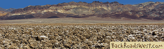
From Las Vegas, the quickest route is to take S.R. 160 to Pahrump and then cut through Death Valley using a variety of roads – mainly S.R. 190. Then take S.R. 136 for the last stretch into Lone Pine. The total trip distance is 225 miles and 95% of it is on a two lane road.
Things To Do
Here is a quick list of some of the things to see and do within a 20 mile radius around Lone Pine. Look below this list for more information about some of them.
|
|
Biking
For mountain bikers, there are numerous trails that create a maze through the Alabama Hills. Take Whitney Portal Road 2.5 miles west out of Lone Pine and find the sign for Movie Road. Turn right, pull off the road and park, then get on your bike and pick a trail heading north towards the rocks.
To the north of Whitney Portal Road, there are miles of dirt roads that are packed full of scenery to keep you busy most of the day. It is easy to imagine hearing the echoes of the Lone Ranger or John Wayne as they ride straight out of western movie history.
For road cycling, there are several hard-surfaced roads that are great for road bikes but be aware that the pavement is often in poor condition because the roads are seldom used. The up side to this, though, is that these roads see very little vehicular traffic. And, even if you do run into some vehicles, because it is so quiet in the Owens Valley, you’ll be able to hear them come from miles away.
Paved roads that are good for road cycling include Tuttle Creek Road and Lubken Canyon Road, which makes a short loop trip starting and ending in Lone Pine. Horseshoe Meadows Road, heading south off of Whitney Portal Road, is a classic thigh-burner with a round trip of 20 miles that will result in a 6,000 foot elevation gain but reward you with outstanding views. If you are looking for a more desolate ride, try taking S. R. 136 from Lone Pine and riding it 36 miles (one-way) to the ghost town of Darwin.
Lone Pine also hosts one of the more unique bike races in May that starts at the lowest spot in the USA, Death Valley, and ends near the highest spot, Mt. Whitney Portal.
Fishing
The Lone Pine area is probably known more for fishing than any other activity. Between Lone Pine and Bishop are lots of streams that flow with cold, fresh water out of the Sierras. If you don’t mind hiking, there are several high-altitude lakes that rarely see a crowd. With all this variety, it is easy to find your own private fishing spot.
Many of the supply stores in Lone Pine cater to fishermen and are good places to start your fishing adventure by talking to the locals and getting their tips.
More…
Pictures
Below are some pictures of what you will see along the way.


Panoramic view of downtown Lone Pine with the Sierras in the background
Shop for Lone Pine items
Scroll down to see and shop for items related to Lone Pine filming history from Amazon.
Books Recommended on Amazon
Virtual Tour on YouTube
Golfing
Lone Pine has one “lone” golf course and because Lone Pine is a sleepy town, it has a sleepy golf course that equates to no tee times and no waiting. Although it is not as fancy as some other golf courses, the mountain scenery here is second to none.
Hiking
Just outside of Lone Pine is one of the most popular hiking trails in the USA – the trail to Mt. Whitney’s summit. Hiking to the summit requires you to be in tip-top shape and have reservations a year in advance. If that sounds a little too daunting for you, you can drive up to Mt. Whitney Portal and hike the first two miles of the trail. You’ll still be able to enjoy some awesome High Sierra beauty.
There are also hiking opportunities in the area nearby Lone Pine. Just south of Whitney Portal is Horseshoe Meadows. Just driving the road to the meadows, which branches off Whitney Portal Road, is an adventure in itself. West of Independence (a town 15 miles north of Lone Pine) is Onion Valley, which is another jumping off spot for several major hiking trails into the Sierras.
Another great place for hiking is Alabama Hills. There are numerous short trails in this area just west of Lone Pine, but you can also forge off into whatever terrain strikes your fancy. One trail not to miss is the short loop hike to Mobuis Arch. See our map for location.
Museums
Lone Pine and Independence both have nice museums. Between the two towns, there are a total of four museums and all deserve a visit. One can easily spend an entire day or more visiting all four museums.
The Lone Pine Film History Museum is one of the most unique museums. It is located just south of downtown on 395. It showcases hundreds of movies that were filmed in the immediate Lone Pine area.
Two miles south of Lone Pine, at the junction of Hwy 395 and Hwy 136 (the road to Death Valley) is the Inter-agency Visitor Center. If you are just rolling in to town from the south or east and you’d like to learn more about the area, stop in here. The visitor center is a great place to get oriented to the attractions in the Owens Valley and Sierras. It also has a great display of the infamous Los Angeles aqueduct built under William Mulholland’s direction.
Halfway between Lone Pine and Independence is the Manzanar War Relocation Center. The museum is located at the entrance. Behind the museum is what remains of a dark piece of U.S. history that happened during World War II, which is where hundreds of Japanese-American citizens were interned during the war.
Independence, the county seat of Inyo, hosts the Eastern Sierra Museum. It displays all types of historical artifacts and information that covers the entire Inyo County – from Bishop to Death Valley.
Off-road Exploring
For the off-road explorer (SUV or Jeep), there are plenty of dirt roads to explore within a 25 mile radius of Lone Pine. You can take your pick of exploring roads either in the desert or up in the high mountains.
One of the more captivating 4WD trips is to the 1870s silver mining ghost town of Cerro Gordo which takes you into the Inyo Mountains. It is on a normally well-groomed dirt road that even the most novice SUVs drivers can handle. The road is extremely steep so people with a fear of heights may not sit easy on this trip. With that said, the views of the Sierra Nevada’s are breathtaking. Cerro Gordo is one of the best preserved ghost towns in California because it is privately owned and cared for.
You can continue your journey past Cerro Gordo and go over to the other side of the mighty Inyo Mountains and down into Death Valley and Lee Flat. A large forest of Joshua Trees grow in Lee Flat and was where an inspired Irish rock group, U2, snapped a photo of one for the cover of their album called “Joshua Tree”.
There are also several other 4WD roads located in the Inyos, most of them more rugged than the one to Cerro Gordo. A very challenging loop road starts in Swansea along S.R. 136 and returns down the road from Cerro Gordo. This road is for very experienced drivers with well-fitted rigs only.
Another road that leads into the Inyos is Mazourka Canyon Road. This dirt road, which takes off out of Independence, is well maintained. It ends at a group of radio towers and offers an outstanding, sweeping view of the Sierra’s.
Other dirt roads located north of Lone Pine pass by long-forgotten towns of the Owens Valley. There are only a handful of dirt roads that climb into the Sierra’s and they don’t go as far as the paved roads of Whitney Portal or Horseshoe Meadows Road.
Photography
As amateur photographers, it is the stunning scenery of the Lone Pine area that’s brings us back to this place again and again. But don’t take our word for it; movie makers from Hollywood have been using the rugged, scenic beauty around Lone Pine since the 1920s.
The Alabama Hills, just west of the town of Lone Pine, is a good place to size up the photographic potential of the immediate area. With its countless rock formations and the backdrop of the craggy Sierra Nevada’s, you can easily see why this scenery ended up in so many movies.
To find your favorite spots, we recommend that you take the entire Movie Road loop. It starts off heading north from the paved Whitney Portal Road. Passing through Movie Flat, countless trails meander off Movie Road to rock formations that would kindle the artistic ability in anyone holding a camera. Just past Movie Flat are a collection of small natural arches. Continue on the road all the way to the Moffat Ranch wetlands where there is a small oasis that attracts wildlife. All along this road, great views of the Sierra’s from different angles are certain to stimulate your creative side.
After you’ve explored the Alabama Hills, be sure to visit the other sites around Lone Pine because they are all photogenic.
Sightseeing & Fall Colors
For the same reason that photographers love the Lone Pine area, people who are searching for a quiet place to relax and enjoy some solitude can find it here. In the month of November and into early December, fall colors add even more beauty to an already scenic place. We have often found the best colors in the Owens Valley in mid-November.
Springtime is also a great place to visit here. In late April to early May, all of the trees are sprouting out new bright-green leaves that seem to glow in the sunlight and the creeks will be more alive with rushing water from the snowmelt, adding that peaceful sound to many areas.
Lone Pine has so much to offer with its history, geology, natural beauty and wildlife, there is something for almost everyone!
Trip Map
The below map points out locations mentioned in our article and video tour, with icons indicating the type of location (i.e. road trip or hike).
Support Us
Help us fill up our tank with gas for our next trip by donating $5 and we’ll bring you back more quality virtual tours of our trips!
Your credit card payment is safe and easy using PayPal. Click the [Donate] button to get started:
Subscribe
See all our comprehensive virtual tour guides at:
![]()