Route 66 From Helendale to Barstow
In its day, Route 66 was a lonely road. There are not too many places close to Los Angeles where you can still experience that same lonely road. However, we know of one place that you can easily get to and feel like you’re the only person on Route 66.
This virtual tour covers the second half of the segment of Route 66 that stretches between Victorville and Barstow. If you missed the first half, make sure to watch it first by clicking here and read about the details. Then you can come back and take this trip.


This virtual road trip starts at the Vista Road intersection with Route 66 near Helendale and Silver Lakes. From here, start the trip by heading north on Route 66. The town of Lenwood, which is inside the city limits of Barstow, is reached in 16 miles. There are no towns between here and Lenwood.
Route 66 Museum
If you haven’t already visited the Route 66 Museum in Victorville, we recommend that you plan on visiting it during this trip to learn more on how Route 66 influenced this area. The museum is well stocked with historic and interesting items related to the Mother Road. See their website for directions and when they are open.
The Trip
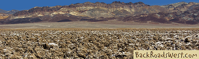
As mentioned in the tour, this segment of the road passes through countryside that hasn’t changed much since National Trails Highway (the predecessor to Route 66) was established in the late 1910s. The same isn’t true for the segment between Victorville and Helendale, where a lot of development occurred in the 20th century.
When driving the road covered in this tour, try to imagine yourself driving a persnickety Model T in the early 1920s. It was quite an adventure. Unlike today’s vehicles, automobiles back then were very sensitive to the environment. Naturally, being in the desert, increased the challenge of operating an old automobile in the harsh desert heat.
More…
Shop for Route 66 items
Scroll down to see and shop for items related to Route 66 from Amazon.
Books Recommended on Amazon
Virtual Tour on YouTube
Burden’s Store & Post Office
About one mile from Vista Road, an old building will be seen on the right. This marks the original spot of “downtown” Helendale, which has since moved to Vista Road. This was Burden’s, which was a store, garage and post office. The small community of Helendale grew up around it.
There is a large cluster of tamarisk trees across the road from Burden’s. The school used to be situated here, with the train station behind it. The house for the school marm was located up on the hill and just to the north of Burden’s, on the same side of the road. Unfortunately, it was torn down around 2008.
Hodge
After about 6.5 miles, you will pass by a sign marking the location of Hodge. There is really no town here, but you will see an increase in buildings.
Before National Trails Highway was established, a popular wagon road followed the Mojave River. Some pioneers used the increased water available here to establish farms. If you venture off onto some of the side roads, you will discover the remnants of old farming activity, as well as some modern farms.
Hinkley Road Turnoff
Just over 11 miles, you will see the turnoff for Hinkley Road on the left. At the northwest corner is the remaining foundations of an old gas station. Several other gas stations existed along this segment of Route 66 and, like all the other ones, went out of business after I-15 was built.
Speaking of old wagon roads, if you turn left at Hinkley Road and drive a half mile and go over the railroad crossing, there is a small historical marker that commemorates all of the wagon and pioneer roads that passed along here, mainly following the lifeline (because of water) known as the Mojave River. Last on the list is National Trails Highway (aka National Old Trails), which was renamed Route 66 in 1927.
The town of Hinkley is located 5 miles north of here. Hinkley received a lot of fame from the movie Erin Brokovich. The site of the PG&E processing plant that was the culprit of poisoning the groundwater supply is actually east of Hinkley. If you would like to see this area, continue on to Lenwood and turn left on Lenwood Road (a traffic light). Cross the Mojave River and then turn left on Community Blvd. You will see the PG&E office on the left in 2.5 miles with the large plant behind it. All around this area, you will see strange devices scattered around the countryside. These are instruments that are constantly monitoring the ground.
Lenwood
Towards the end of this segment of Route 66, you will enter the town of Lenwood. Before reaching the traffic light (the first one encountered since Victorville), there is some interesting ruins on the right. An old hotel called the Do-Drop Inn is behind a fence. There used to be some interesting signs on the property, but they have been removed.
Behind the hotel and to the southwest (just before reaching the hotel on the road), there used to stand a classic landmark, the Bar-Len Drive-In. The name obviously came from Barstow-Lenwood. Drive-in theaters used to be a common sight when traveling along Route 66 in the 1950s and 60s. Not very many exist anymore – anywhere. However, one still exists and still operates north of Barstow near the junctions of I-15 and Old Highway 58.
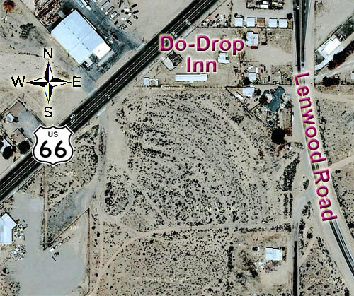
If you drive into the dirt lot just south of the Do-Drop Inn, you can still see some ruins and the dirt mounds that cars parked on to watch the big screen. Above is a picture from Google Earth that shows the footprint of the drive-in with the rows fanning out from the big screen which was located in the southwest corner of the lot.
Continue going north on Route 66 to see downtown Lenwood, which is a classic small town. You can also turn right onto Lenwood Road to reach civilization, as the popular Lenwood Outlet Malls are located at the road’s intersection with I-15, where there are many eateries and gas stations.
Trip Map
Support Us
Help us fill up our tank with gas for our next trip by donating $5 and we’ll bring you back more quality virtual tours of our trips!
Your credit card payment is safe and easy using PayPal. Click the [Donate] button to get started:
Subscribe
See all our comprehensive virtual tour guides at:
![]()