San Andreas Fault Through Carrizo Plain
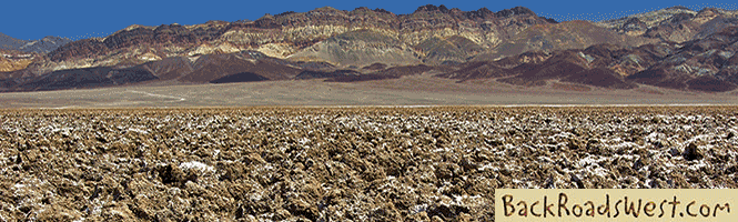
Continuing our series of road trips along California’s infamous San Andreas Fault, this tour takes you through the remote Carrizo Plain National Monument, which is located roughly halfway between Bakersfield and San Luis Obispo. No other place in California shows off the long and straight ridgelines created by the fault’s grinding action better than the Carrizo Plain. Plus, this single, lonely road through the monument can definitely be classified as a “back road”.


Grasslands
Along with geologic sightseeing, the Carrizo Plain boasts some of the last remaining native grasslands in California. This was the primary reason why it was granted National Monument status in 2001. At one time, most of California’s Central Valley (San Joaquin and Sacramento Valleys) were completely covered with the same grasslands seen at Carrizo. Since the 1800s, those grasslands in the Central Valley have been replaced with agriculture and are now one of the most productive agricultural regions in the world.
We would often take the road through Carrizo Plain as a shortcut when going on a long-weekend jaunt to the Central California coast when we lived in Southern California. The road is a mix of eroded pavement and dirt and stretches for 45 miles from Hwy SR 166 (in the south) to SR 58 (in the north). The road is drivable by most vehicles and is notoriously dusty with patches of bumpy washboard. We’ve driven our car on it several times.
Earthquake Fault Features
For half its distance, the road runs alongside the San Andreas Fault zone. As the road enters the large valley of Carrizo Plain from the south, it veers away from the fault for a while but don’t worry. Our route takes you to some of the classic features you’ll want to see on the fault line.
Some of those classic features include linear ridges, trenches, scarps and off-set stream channels. These features mark the location of the fault as well as showing the direction that these land masses are moving as they slide past each other. The wide-open spaces of the Carrizo Plain make these features easy to see.
Long, linear ridges and trenches mark the fault along the entire length of Carrizo Plain where the fault zone is only a hundred feet wide or less. These linear features are what geologists call “shutter” and “pressure” ridges and they are exclusive to strike-slip faults such as the San Andreas. Here is where the two land masses slide past each other horizontally at an average speed of 1.5 inches per year. That’s about as fast as your fingernails grow.
Shutter ridges occur when a high spot along the fault is moved, over time, to a low spot creating a linear step. Pressure ridges are formed when the two land masses compress against each other, causing the land to abruptly rise or bulge. Sometimes, the strike-slip action creates a linear trench. In other places, a scarp is created which looks like a small step or off-set in the landscape. These are created during the actual moment of an earthquake. You’ll see plenty of examples of all these features along this road trip.
Off-set stream channels form when a drainage or creek bed that was previously straight is moved and becomes off-set by thousands of years of fault movement. The result is a creek bed that is straight for a stretch then, when it crosses the fault it turns 90 degrees, goes a short distance and then turns 90 degrees again to continue its path in the original direction. For geology geeks, one of the most well-known off-set stream channels is Wallace Creek and our tour stops there.
You can see animated examples of these features on our Virtual Video Tour (below) as well as where to find them along the tour and what they look like. Be aware that many of these features are difficult to see from the ground so you really need to see them from above first. That’s why we included several Google Earth video sequences to highlight some of the features.
When driving through the Carrizo Plain, it seems like a vast, flat surface with rolling hills but when flying in an airplane just a few thousand feet high, the swath of the San Andreas bisecting the Carrizo Plain is a dominant landmark. On maps, this dominant landmark is called Elkhorn Scarp. Our Virtual Video Tour includes aerial views of the fault along our tour’s route, so be sure to watch it before taking your trip there.
More…
Pictures
Below are some pictures of what you will see along the way.


Driving Route
The route can be driven in any direction. In the video, we’ll drive it from SR 58 to SR 166 (north to south). Starting on SR 58, we’ll visit the spot where the San Andreas crosses the highway. This spot is very obvious, as the pavement dives down over a large shutter ridge. This spot along SR 58 is located either 20 miles from SR 58’s intersection with SR 33 to the east, or 50 miles from downtown Santa Margarita (near US 101) to the west.
From there, we’ll drive a few dirt roads to visit the Wallace Creek site. Then, we’ll drive southwest across Carrizo Plain to the main road through the National Monument – Soda Lake Road. Once on Soda Lake Road, we’ll pass by the other dominant feature in Carrizo Plain, Soda Lake (the road’s namesake). Similar to playas found in the Mojave Desert, this sometimes-dry lake simmers with a very bright, white surface.
Once on Soda Lake Road, we’ll head southeast along the shore of Soda Lake. Near the playa’s center, there is a short road that climbs a nearby hill, called Overlook Hill, which provides a great view of Soda Lake and the entire Carrizo Plain. Continuing south on the road for a short distance brings you to the Goodwin Education Center, the Monument’s visitor center. South of the visitor center is a hiking trail that leads to a Native American pictograph site.
Back on Soda Lake Road, continue south as it eventually takes you back closer to the San Andreas Fault. The remoteness of the Carrizo Plain is felt even more here as there are fewer traces of civilization. The valley then narrows and becomes a linear valley created by the fault’s movement. The road passes just along the fault zone, giving you good views of the features discussed earlier plus a few sag ponds. Finally, Soda Lake Road ends at SR 166, where the restored remains of an old Union 76 gas station survive.
From SR 166, you can either head east to I-5 and Hwy 99 to Bakersfield, head west to Santa Maria and US 101, or continue driving along the San Andreas. If you wish to do the latter, where Soda Lake Road T’s into SR 166, turn right, go about 100 feet, then turn left onto the next paved road which is named Hudson Ranch Road on most maps. This road will continue following the fault through Pine Mountain Club (a town), Frazier Park and, in 40 miles, end at the I-5 freeway. We will soon have a road trip tour that covers this segment of the fault.
Trip Map
To help plan your trip, check out our interactive Google Map below.
Support Us
Help us fill up our tank with gas for our next trip by donating $5 and we’ll bring you back more quality virtual tours of our trips!
Your credit card payment is safe and easy using PayPal. Click the [Donate] button to get started:
Subscribe
See all our comprehensive virtual tour guides at:
![]()