Southwest Utah: A Triple Junction of Landscapes
Those of us living in the Southwestern United States often take the scenery we see out of our windows for granted. Sometimes it takes a trip to other areas of our country, like Ohio, Mississippi or Kansas, to realize just how special our landscape really is.

In Southwest Utah however, the landscape is especially scenic and unique due to the junction of three well-known physiographic provinces: the Colorado Plateau, Mojave Desert, and Great Basin. This article provides a “best guess” as to how the scenery came about due to the influences from these three provinces, and where to go see them.
In This Article
- Videos
- About Southwest Utah’s Triple Junction
- Where to see the places explained in the first video, part #1
- Where to see the places, part #2
- About the Triple Junction and the 3 physiographic provinces
- Where to See the Triple Junction
- Map of stops along video tour 1 & 2
Videos
Below are the three videos on YouTube that cover the topics covered in this article.
About Southwest Utah’s Triple Junction
This video presentation explains how and why the scenery was formed in Southwest Utah, around the city of St. George.

Where to Find the Scenery, Part 1
This video tour shows where to find the scenery that was mentioned in the first video that shows the influences of those three physiographic provinces.

Where to Find the Scenery, Part 2
The continuation of the tour starting from the Hurricane Fault, going east.

Would you like to physically go on a tour to see these places? Read below:

About the Triple Junction
Let’s explore some of the reasons why our landscapes look the way they do. To do so, first we need to know a little bit about the different provinces and how they each have their own unique forms of recognizable landscape. Then we’ll talk about a place where three of these provinces come together and you can see influences from each of them mixed together in one place.
When we drive down a highway that has expansive views of the scenery, knowing a little bit about what we’re looking at makes the views that much more interesting. Once you begin to recognize some of the common elements of a province, it becomes almost like putting together a gigantic jigsaw puzzle as you try to piece together and make sense of what you’re seeing.
The 3 Physiographic Provinces
Three of the most well-known physiographic provinces in the Southwest are the Mojave Desert, the Colorado Plateau and the Great Basin. Each of these provinces has its own unique form of geology, botany, climate and other elements. Because geology is such a huge and complicated topic, we’ll be giving you a condensed version of what these provinces are about in this article. For more information, watch our virtual video tour by following the link at the end of the article.
Colorado Plateau
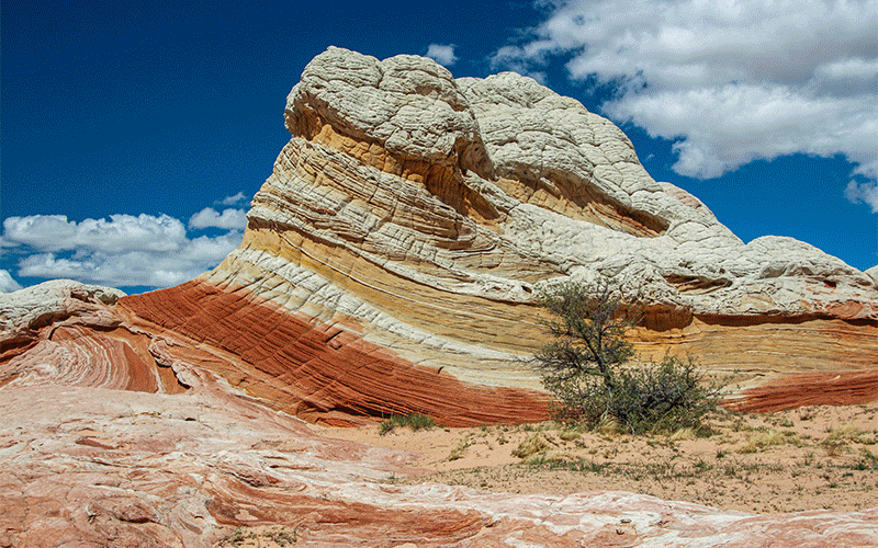
The first province we’ll talk about is one of the most special – the Colorado Plateau. Within this province is some of the most striking natural scenery in the world. It includes the Grand Canyon, Zion, the Grand Staircase, Canyonlands, the Painted Desert, and many other well-known places. Unlike the other two provinces, the Colorado Plateau is made up of noticeably well-organized layers, which is obvious when you look into the Grand Canyon. These same horizontal layers are visible in most areas of the Plateau, with each layer made up of a distinctive color and soil type. Geologists call these layers “formations”.
One of the most recognizable of these formations is Navajo Sandstone. Its distinctive reddish-orange color can be seen throughout the Plateau, as well as in places of the Mojave Desert. As the word “sandstone’ implies, the material originally came from sand dunes, then as more material deposited on top of it, the sand solidified and became rock (stone) – sandstone. Later, the iron compounds in the sand “rusted”, giving it its reddish color. Then, later still, water and wind erosion created the spectacular canyons, such as Zion, that we see today.
The Colorado Plateau Rises
At some point in time, an interesting thing happened to the Plateau: it started to rise. In some places, it rose over a mile in a half! Powerful forces from adjoining provinces, such as the Great Basin, pushed up against the Colorado Plateau block, causing it rise. At the edges of the Plateau, where it broke away from the rest of the land, are two large and obvious “cracks”, also known as faults (the same thing that causes earthquakes). One is the Hurricane Cliffs/Fault east of St. George, Utah, and the other is the Mogollon Rim near Sedona, Arizona. Each are easily visible today and firmly define the border of the Plateau. If the soils of the Plateau had never eroded after it started lifting, those cliffs would now be over a mile-high today!
The combination of these well-organized formations, each with their own characteristics, that were later eroded away into countless geologic features, is what gives the Colorado Plateau some of its most iconic landscapes.
More…
Pictures


Mojave Desert
The next province is the Mojave Desert. The Mojave is probably best known for its iconic Joshua Tree but it is also the smallest and driest desert in the United States. Because Joshua Trees typically only grow in the Mojave Desert, they are an easy way to identify this province.
In addition to having its climate effected by being in the rain shadow created by California’s large mountain ranges, this province also has unique geology. A long portion of the Mojave’s southwestern border is none other than the San Andreas Fault. In this province, many mountain ranges trend (or run along) the same direction as the San Andreas. This caused geologists to conclude that there is something called the “Mojave Rift Zone”. In recent history, more earthquakes have occurred within this rift zone in the southern Mojave Desert than on the San Andreas itself. This means that this zone is more active with movement than other places in the Southwest.
Great Basin
Next up is the Great Basin. Roughly, this is the region between the Hurricane Fault (western edge of the Colorado Plateau) and the Sierra Nevada Mountains in California. This is a region where rain falls and, in most cases, doesn’t flow to the sea. It is caught in large “basins”. Some people confuse the Great Basin province with the larger geologic region known as the Basin and Range. The Basin and Range region is named after the valley (basin) and mountain (range) building that is occurring from Idaho all the way down into Mexico. These valleys and mountains do not all trend in the same direction. In the Great Basin province, although it has the same “basin and range” topography in most of Nevada, these basins and ranges trend parallel to both the Hurricane Fault and the Sierras.
Utah’s Triple (3-way) Physiographic Junction
So, now that you know a little about these three provinces, where is this place where they all meet? It is in southwest Utah at a place some people call the “triple junction”. Here, within about a 50-mile radius of the town of St. George, you will find attributes and features of all three provinces mixed together.
What’s especially interesting is that, on the east side of the Hurricane Fault (the Colorado Plateau province), all of the horizontal layers (formations) are very level and organized. But on the west side, they are all jumbled up. That’s because the west side of the fault (the Mojave Desert and Great Basin provinces) is being torn apart by geologic forces influenced from other places. This makes for some very unique landscapes and scenery in this area.
Be sure to watch our YouTube video presentation above to fully visualize the triple junction.
Where to see the Triple Physiographic Junction
Around the area covered in the videos, there are places to see all three physiographic or ecosystems at once. Here’s the best places:
La Verkin Overlook
As mentioned in the first video tour, this overlook that can be reached from SR 9 between the towns of La Verkin and Virgin (on the way to Zion National Park) is one of the best places to see the junction. The overlook sits on top of the Hurricane fault.
The entire east side of the fault is the Colorado Plateau, where as the northwest quarter is the Great Basin and the southwest quarter is the Mojave Desert.
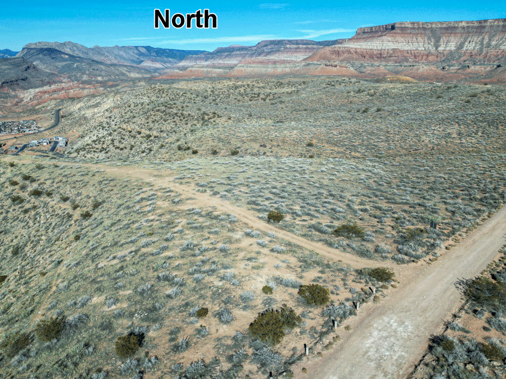
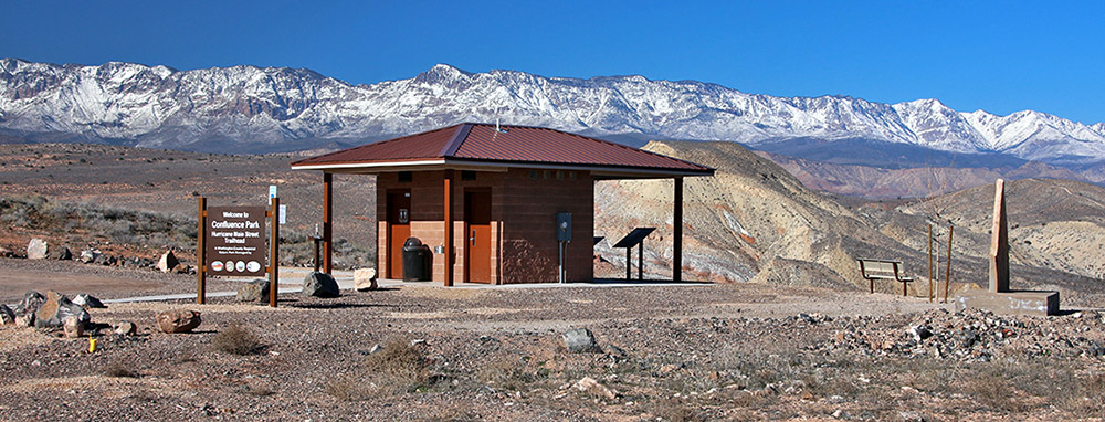
Confluence Park Trailhead
In the town of Hurricane, at the very northern end of Main Street, is Confluence Park. It is labeled as the Virgin River Trailhead on Google Maps. Looking to the north, you can see the Colorado Plateau on the right, and the Mojave Desert and Great Basin on the left.
At the trailhead and restroom, there is a number of kiosk signs that points out places of interest. One sign explains the geology in the area, including the junction of the three provinces.
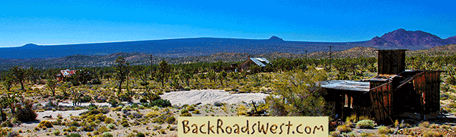
Silver Reef
Also as mentioned in the video, the historic townsite of Silver Reef is a great way to see the Triple Junction. It is due west from La Verkin Overlook and at the eastern base of the Pine Valley Mountains.
Silver Reef is roughly located at the very eastern edge of the Great Basin. Nearby though, is the beginning of the Mojave Desert.
Map
To help plan your trip, either use our interactive Google Map below or download our GPX file that points out the places covered in this tour.
Click here to download our GPX file of all the tour stops mentioned in the Triple Junction tour. View the stops using a GPS mapping app, such as Gaia GPS or Google Earth, so that you can navigate to each stop. Click the ad below to purchase Gaia GPS using our discount code which offers up to a 50% discount.

Learn more about our maps.
Conclusion
We hope you enjoyed our article explaining why there is spectacular scenery around Southwest Utah. See information about taking a private tour of this area at our BackRoadsWest travel guide website.
Comments
Read and leave comments about this post on YouTube.
Support Us
Help us fill up our tank with gas for our next trip by donating $5 and we’ll bring you back more quality virtual tours of our trips!
Your credit card payment is safe and easy using PayPal. Click the [Donate] button to get started:
Subscribe
See all our comprehensive virtual tour guides at:
![]()