Fall Colors Above Cedar City Utah
Would you like to see some of the best fall colors in all of Southwest Utah? And maybe the best fall colors in the tri-state area of Arizona/Nevada/Utah? Then head to the mountains above Cedar City, Utah, near Cedar Breaks National Monument (or as the locals call it, Cedar Breaks).


Trip Specs
Length
Attractions
- Fall colors
- Great views
- Volcanic features
Difficulty
- Some roads require 4WD
- High elevations
Elevation Gain
What’s in a Name?
We have heard many different names for this area over the years but the official name of the large mountain range east of Cedar City is the Markagunt Plateau. Our guess is that there are so many names simply because it’s difficult to pronounce and remember “Markagunt”. But whatever you call it, this trip will focus on the spectacular fall colors that can be found to the east of Cedar Breaks.
Pronounced “Mark-ah-gunt”, it is a series of plateaus in south central Utah. Other neighboring plateaus include the Paunsaugunt, Aquarius and Kaiparowits. Bryce Canyon National Park is located on Paunsaugunt.
Some of these plateaus were pushed up over the last few million years. Obvious signs of volcanism can be found all over the Markagunt. According to geologists, volcanic activity occurred on the Markagunt starting roughly 5 million years to just 11,000 years ago.
Getting There
Getting to this area is quite easy. Take I-15 to Cedar City and follow the signs for Cedar Breaks National Monument. You’ll find yourself heading east on Hwy 14. As you leave Cedar City, Hwy 14 enters the narrow and colorful Cedar Canyon and begins its steep climb from 5,800 feet to 10,000 feet in about 18 miles.
For those that don’t know where Cedar City is located, it is about a 45 minutes (50 miles) north of St. George, Utah and about 2.75 hours (175 miles) from Las Vegas, Nevada.
Once you are on top of the Markagunt Plateau, there are several areas you can go to view large stands of trees turning bright yellow, orange and red. We’ll point you to some of our favorite places to find some of those amazing colors.

Fall Colors – When?
Most of the trees that turn color are aspens but there are also small maples. There are large groves of aspen trees throughout the Markagunt Plateau and they are common above 8,000 feet. The maples tend to like the steep, narrow canyons on the mountainsides above 6,000 feet throughout Southwest Utah.
As with most fall color displays, the window of time to see them is rather small and unpredictable and is dependent on the weather. Around here, maples typically start turning their distinctive red color in mid to late September. As you may know, aspens turn color at the higher altitudes first and, as the colder temperatures move down to the lower altitudes, those trees start to turn.
In most mountains around the Southwest, aspens start their change around the last week of September and it lasts until the second week of October. However, on the Markagunt Plateau, the aspens usually turn during the two-week window around of October 1, plus or minus one week.
One sure way to find out if the trees are turning color or not before making a trek to these places is to find out first-hand from a local. Here are a few places you can try calling or monitoring a week before your planned trip:
- Cedar City Visitor Center (visitcedarcity.com)
- Cedar Breaks National Monument Visitor Center (website)
- Brian Head Resort (brianhead.com)
- Any business in Duck Creek Village
More…
Pictures
Below are some pictures of what you will see along the way.


Our Suggested Route
Here is our suggested route for seeing the fall colors. After summiting on Hwy 14 near the turn-off to Cedar Breaks, continue straight on Hwy 14 to Duck Creek (12 more miles). Just before reaching Duck Creek Village, look for signs pointing to Aspen-Mirror Lake. Take the short dirt road to the end where there’s a restroom and a gate. Walk past the gate about a quarter mile to reach the small lake. The reason we’re stopping here first is because there is typically no wind in the morning. This is important if you want to experience the “aspen mirror” effect – that perfect reflection of the aspen trees on the southwest side of the lake.
Our next stop will require an SUV or vehicle that can navigate on an easy dirt road. If that’s you, head back west on Hwy 14 for 9.5 miles and turn right onto Forestry Road 240. Just after turning onto the dirt road, bear right to continue on 240. Continue for about 5 miles to enjoy many great stands of aspens. About 3 miles in, you’ll pass through Horse Pasture. Across the meadow to the south is an expansive volcanic basalt (lava) flow and within that basalt are small colonies of aspens. The bright yellow colors of the trees create a striking contrast to the black basalt, making this a unique place to see fall colors.
Return to Hwy 14 and turn right towards Cedar City. Then turn right onto Hwy 148 and drive through Cedar Breaks. Turn right onto Hwy 143 (to Panguitch Lake) and reset your odometer. At 5 miles, turn right on FR 240 – yes, this is the same dirt road we were on earlier. It connects to Horse Pasture but it becomes very rough and rocky halfway through so it’s easier to backtrack and start your journey over again here.
In just under half a mile, FR 240 crosses Mammoth Creek. Park here and look to the right (up the creek). Located along the right of the creek is a big stand of aspens that are usually in various stages of turning from yellow to red. More colorful trees can be found on 240 after crossing Mammoth Creek on the left.
To see even more aspen, continue on 240 for another 5 miles from the pavement. Look for a large cinder cone called Hancock Peak on the right that is usually ringed with colorful aspens. 240 then passes through a long meadow, labeled as Red Desert on most maps, that has aspen trees on both sides.
When you’re finished exploring this area, head back to Hwy 148, then turn left towards Hwy 14 to descend back to Cedar City. If you have time remaining, rather than turning left on 148, turn right, go 1.4 miles, then turn right onto the dirt road that climbs Brianhead Peak. From atop the 11,300 foot peak, you’ll be able to see over most of the Markagunt and all of its brilliant fall colors.
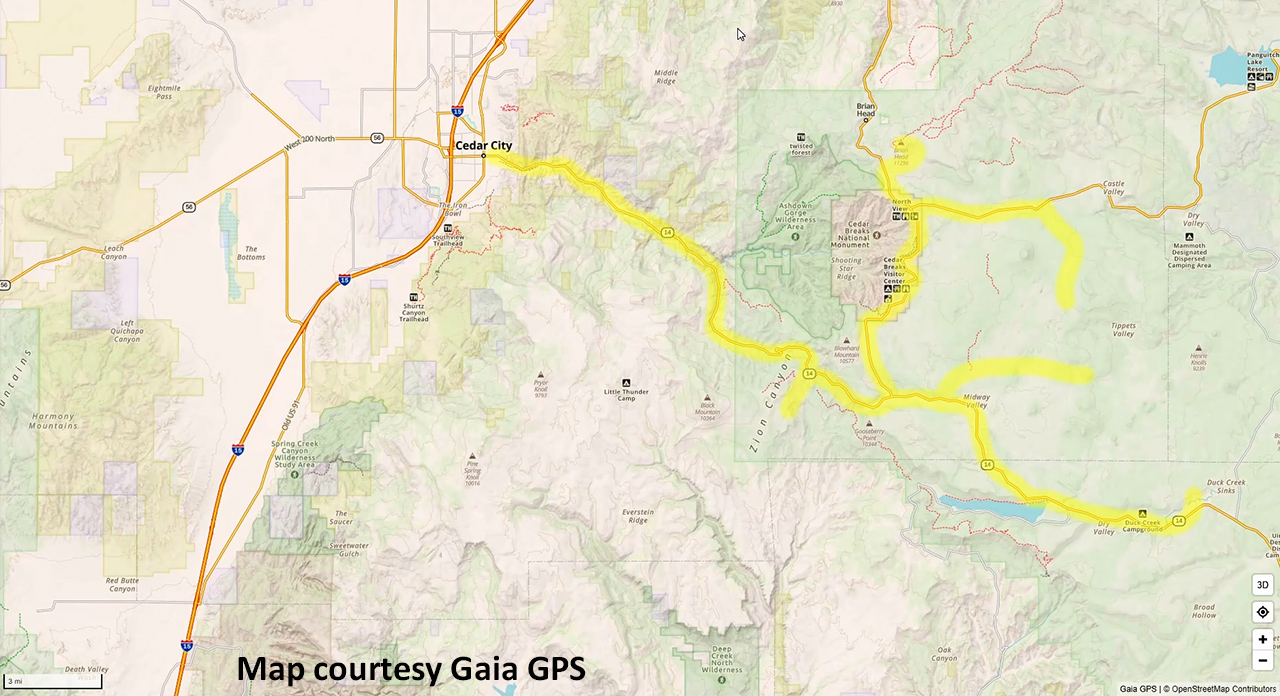
Trip Map
To help plan your trip, either use our interactive Google Map below or download our GPX file that points out the places to see that are mentioned in this chapter.
Click here to download our GPX file that follows our tour of the fall colors in the mountains above Cedar City. We recommend using a GPS mapping app, such as Gaia GPS, to view these points on your computer or to locate them using GPS with your mobile device or phone. Click the ad below to purchase Gaia GPS using our discount code which offers up to a 50% discount.

Learn more about our maps.
Comments
Read and leave comments about this post on YouTube.
Support Us
Help us fill up our tank with gas for our next trip by donating $5 and we’ll bring you back more quality virtual tours of our trips!
Your credit card payment is safe and easy using PayPal. Click the [Donate] button to get started:
Subscribe
See all our comprehensive virtual tour guides at:
![]()