Grand Canyon Flightseeing
Being one of the Seven Natural Wonders of the World, the Grand Canyon is an amazing, jaw-dropping sight to see. There are lots of ways to see the Grand Canyon. Most people see it from its South Rim, fewer see it from its North Rim and even fewer people see it from a remote viewpoint such as Toroweap Overlook, Twin Point, or Point Sublime or by hiking into it.


Many people also see it from an airplane, usually flying on a commercial flight at over 20,000 feet, but at that that altitude, it just looks like a huge hole in the surface of the Earth with no real sense of depth.
Small Plane
We recently discovered that one of the absolute best ways to see the Grand Canyon is from a small plane that flies just a few thousand feet above the rim. This top-down, close-up vantage point allows you to see so much more than any of the other methods of visiting. It is awesome!
Our custom flight over the central part of the Grand Canyon began by having a discussion with our pilot. We explained where we wanted to go and what we wanted to see and, based on his familiarity with the canyon, he gave us suggestions and determined our flightpath.
Hurricane, Utah
The flight started and ended at Hurricane airport which is not far from St. George and Zion National Park (all in Utah). The central part of the Grand Canyon is located about 70 miles south of Hurricane, which isn’t really a long distance when you’re flying at around 100 mph.
Spectacular Geology
Along with flightseeing over the Grand Canyon itself, there are a lot of other interesting sights to see between our airport and the canyon. Southwest Utah and Northern Arizona are both full of spectacular geology. Wherever you look there’s something incredible to see and, as amazing as it is to see it from the ground, it all looks a lot different from up in the air.
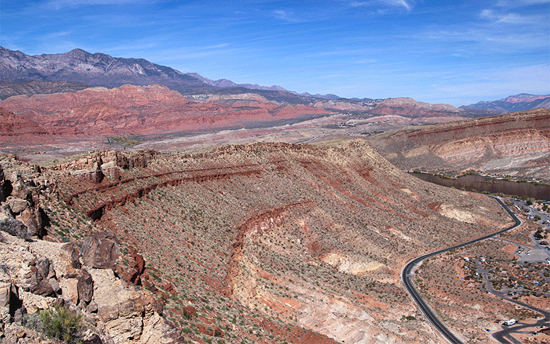
Our flightpath took us straight south following the Hurricane Fault which is a long, 1,200 foot-high vertical rupture in the Earth’s surface. This fault marks the western boundary of the Colorado Plateau and both the fault and plateau play a significant role in the creation of the Grand Canyon itself. Seeing the fault from the air really gives you a good sense of just how significant this geologic boundary is.
Another spectacular geologic formation that is best seen from a small plane can be seen just south about 10 miles south of the Hurricane Airport. Geologists call this the Shnabkaib Fold. This is a rare folding of the Moenkopi Formation that is commonly seen on the sides of mesas east of Hurricane. It looks like a gigantic wave and can only be appreciated from the air. Geologists claim that the fold occurred when the weaker Moenkopi Formation succumbed to plastic deformation, when the nearby Virgin Anticline was being formed.
More…
Pictures
Below are some pictures of what you will see along the way.


Whitmore Canyon & Bar-10 Ranch
After passing by the Bar-10 Ranch, a jumping-off point for many Grand Canyon river-runners, we reached the main part of the canyon and the Colorado River. We then turned left, or east, to go up-canyon.
This area of the canyon experienced a lot of volcanic activity. The ancient basalt (dried lava) flows are easy to spot from the air. As we passed over them, we could see where they once flowed downhill in their liquid, lava form and then plunged over the edge of the canyon and into the deep gorges around a million years ago.
Geologists say that the lava dammed up the Colorado River several times and created reservoirs of water behind them. When the water finally broke through, it caused gigantic flashfloods down-river.
Flying Up-Canyon
As we continued flying up-canyon, we passed by many remote sections of the canyon that are seldomly seen by humans except for river-runners. When you’re up in an airplane at about 9,500 feet, or about 4,000 feet above the top of the canyon, it is truly amazing to see how vast the Grand Canyon really is. You just can’t see it all from the viewpoints along the rim.
Havasu Canyon & Havasupai Reservation
There are several flight-restrictions over the Grand Canyon. One is Havasu Canyon, home of beautiful Havasu Falls, which is on the Havasupai Reservation.
On our flight, we were able to see Havasu Canyon in the distance but unable to see the town of Supai, the Native American village that sits near the bottom of the Grand Canyon. It was near Havasu Canyon where we turned and ended our flightpath up-canyon.
Kanab Creek
After traveling up-canyon for about 40 miles, we turned left (north) up a major arm of the main canyon called Kanab Creek (which originates just south of Bryce Canyon National Park). This side canyon is nice for small aircraft because they can legally fly below the rim of the canyon. In the National Park section of the canyon, there are various flight restrictions depending on the type of flight and aircraft. Generally, aircraft need to stay above around 9,000 feet.
The canyon that is being carved out by Kanab Creek looks very different than the main part of the Grand Canyon. This is because Kanab Creek cuts through different rock layers than those being cut through by the Colorado River.
Zion & Canaan Mountain
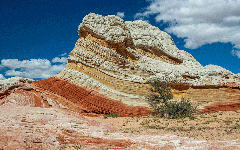
Our flightpath continued north towards Zion National Park and for a long time in the distance we could see the towering red and white cliffs and monoliths of the Zion area. We passed over an area of swirling, colorful sandstone just outside of Zion called the Canaan Mountain Wilderness. Again, viewing this area from the air is best because these mesas sit on top of high red cliffs and are not visible from any road. The only other way to see this beautiful area is by going on a very long and strenuous hike.
After being up in the air for two hours and fifteen minutes and traveling 220 miles, we returned to Hurricane Airport. We saw some breathtaking scenery and, as amazing as that was, we realize that we had only seen a small piece of the whole Grand Canyon. The sheer size and vastness of this area is difficult for us small humans to fully grasp. It really is a “wonder of the world”!
Comments
Read and leave comments about this post on YouTube.
Support Us
Help us fill up our tank with gas for our next trip by donating $5 and we’ll bring you back more quality virtual tours of our trips!
Your credit card payment is safe and easy using PayPal. Click the [Donate] button to get started:
Subscribe
See all our comprehensive virtual tour guides at:
![]()