Gold Butte National Monument
Gold Butte: How to visit – What to see
Ready to go on an overland adventure that is seemingly far, far away, yet close to civilization? Nevada’s newest National Monument, Gold Butte, offers a lot of wide-open desert scenery, colorful and uniquely shaped rock formations, dozens of archeological sites, and miles of back roads to enjoy. Mesquite, 80 miles north of Las Vegas, makes for a great jumping off point to spend a day exploring Gold Butte.


Trip Specs
Length
Attractions
- Mojave Desert scenery
- Native American Rock Art
- Colorful rock formations
- Historic sites
- Desert flora
Difficulty
- High clearance vehicle, might need 4WD
- 40 miles on broken paved road
- Very remote area
- No phone service
- No services
- Navigation skills needed
Elevation Gain
Introduction
Sandwiched between Lake Mead, Grand Canyon National Park and Grand Canyon-Parashant National Monument, Gold Butte preserves a unique corner of the Mojave Desert. Similar to the Mojave National Preserve 100 miles to its southwest, Gold Butte sets aside pristine desert scenery for future generations.
Along with its classic Mojave Desert scenery, Gold Butte is also known for its abundance of Native American rock art, including the well-known Falling Man petroglyph. Another popular attraction in Gold Butte is a unique area of intricate geological formations called Little Finland. There’s also a ghost town where a short-lived mining boom took place at the beginning of the 20th century.
Gold Butte National Monument covers just under 300,000 acres. It was designated in December 2016 after a lengthy campaign by campaign by local conservation groups and the Moapa Band of Paiute Indians.
On this tour, we’re going to take you on an 88-mile round trip loop tour through the Monument but first, here’s some general information you should know before you go.
Best Time to Visit
Our favorite times to visit Gold Butte is March and April. This is when we have seen some dazzling wildflower displays.
After the month of May, it can be too hot to visit and it is definitely too hot to visit between June and mid-September. The best times to explore and enjoy the Monument are from October until early May.
Road Conditions
Keep in mind that Gold Butte is a very remote area with little to no cell phone service. Be prepared with water, food, fuel and common sense.
Regular cars can handle the paved portion of the road, but we don’t recommend that you attempt any of the dirt roads. Stock trucks and SUVs can normally handle those roads but, like any desert dirt road, they are subject to change over time or after a significant weather event. Most 4WD vehicles and ATVs with all-terrain tires can tackle these issues but you might want to consider going to Gold Butte with another vehicle or more for safety.
Getting There
We start by taking exit 112 (Hwy 170) off I-15. This exit is 70 miles northeast of Las Vegas and 9 miles west of Mesquite.
From the I-15 intersection, go south for a few miles. Just after crossing the Virgin River, turn right onto Gold Butte Road and reset your odometer. The badly aging pavement of this road stretches for 21 miles and is full of potholes, so be careful.
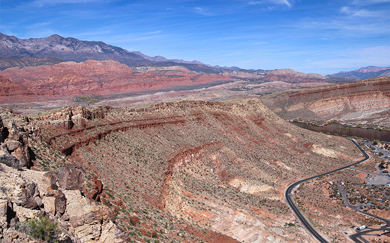
This loop route is called the Gold Butte National Backcountry Byway (see picture below) and there are signs throughout the Monument indicating its path. And, on a map, it’s shaped like a great big lollipop with the handle being the paved section and the approximately 50-mile round dirt portion being the lollipop.
More…
Pictures
Below are some pictures of what you will see along the way.


The Tour
For the first few miles, you’ll pass by ranchland paralleling the river. The road turns left (away from the river) and begins climbing a gentle slope.
At 12.5 miles, you’ll cross the National Monument boundary. A few miles past that, look to the right for Lake Mead off in the far distance.
Bajada
The road then crosses a very large alluvial slope called a bajada. Here is your best bet to see wildflowers in the spring. There are also a wide variety of desert plants to see in this area. Near one of the gullies, park your vehicle here and walk up the bajada to inspect some the of the plants. You’ll find all types of different species.
A bajada is formed when two or more alluvial fans overlap each other. All of the canyons exiting the Virgin Mountains to the east (left) of the road deposit rock and debris over the landscape. These alluvial fans are created as the debris continues to build up over thousands of flood events, then they overlap each other to create one large bajada. It is all the jumbled rock and dirt that becomes great soil for the desert plants to grow in.
Falling Man
At 19.7 miles, a dirt road goes off to the right and leads to the Monument’s largest collection of rock art and a maze of colorful rock formations. You can easily spend a whole day here and still not see everything.
Venturing down this road about 2 miles, you’ll reach the trailhead to the Falling Man or Luke Whitney petroglyph site. Located here is a hiking trail that leads around a maze of colorful rock formations and petroglyph panels. The trail is a little difficult to follow and explain. For that reason, we will be publishing a separate article to cover this hike and all the interesting things to see here.
Continue on the road past the Falling Man trailhead to reach more points of interest. In about one mile, the road passes through a restoration area for the endangered and sensitive Las Vegas bear poppy flower. When we passed by here in mid April, we saw several plants blooming.
Less than a half mile further, turn onto a road that goes left. The road ends shortly at another trailhead. Walking up the wash and a little to the left will take you to the 21 Goat petroglyph panel. Another trail that leads slightly to the right of the trail heads up to an old rancher’s dam and reservoir.
Whitney Pocket
Back on Gold Butte Road, continue for another 1.5 miles to reach Whitney Pocket where the pavement ends. In this area are more colorful rock formations, an ATV staging area with restrooms, places to camp, and a historical dam built in the 1930s by the CCC (Civilian Conservation Corps) that looks like a miniature Hoover Dam.
The road that heads east past the dam leads into Arizona and Grand Canyon Parashant National Monument. To resume out tour of Gold Butte, continue on the main road to the south.
Little Finland Area
On down the main dirt road, about 3.5 miles past Whitney Pocket, we turn right onto Mud Wash North Road. This road takes us down into a fun, twisting desert wash and, in a few miles, we pass by vividly orange sandstone outcroppings where there are more petroglyphs.
A few more miles down the road and we’re near Little Finland, which is not visible from the road. This is another place where you can easily spend all day exploring and looking at these other-worldly rock formations.
See our separate blog post on Little Finland for more details on this amazing place.
Red Bluff Spring and Mud Wash Narrows
Continuing down the road another 5 miles, we arrive at Red Bluff Spring, which is marked with a fence across the wash and the road turns south (left). Here, you can go on a 2-mile roundtrip hike through a small desert oasis and then into a narrow canyon called Mud Wash Narrows.
The hike follows Mud Wash down a canyon with high walls on each side. After about a mile, the wash enters Mud Wash narrows, which is a very unusual slot canyon. In some places, your path may be wet and muddy. Walk down the narrows as far as you wish, then turn around and return to your vehicle following the same path you took in.
Seven Keyholes
About 1.75 miles past Red Bluff Spring, a road will bear to the left and continue somewhat parallel with the main road. This road leads to a unique slot canyon called Seven Keyholes.
See our separate blog post on Seven Keyholes.
Remote Section
Gold Butte’s Backcountry Byway now heads due south and passes through a more remote portion of the Monument. Along this portion of the road, you’ll pass through pristine Mojave Desert landscapes and vegetation.
One of the only roads leading to the right goes down to the mouth of Lime Canyon. At the end of this road, one can hike into rocky Lime Canyon.
Gold Butte
In 14.5 miles, we’ve reached the townsite of Gold Butte. Gold was discovered here in 1905 and quickly 2,000 people were residing here in search of gold. Most left by 1910. Like many ghost towns, there’s not much left here except for a few foundations, some dilapidated mining equipment and gravesites of two of the town’s residents that hung on until the 1950s.
From here, head north on the same Byway and in 20 miles, we complete the loop and are back at Whitney Pocket. Then, it’s another 20 miles back to civilization on the so-called “paved” road.
Another way to learn about Gold Butte is to visit www.FriendsOfGoldButte.org. This organization supports the Monument and have a visitor center in Mesquite. Their handy map is invaluable when visiting the Monument.
Trip Map
To help plan your trip, either use our interactive Google Map below or download our GPX file that points out the places to see that are mentioned in this chapter.
Click here to download our GPX file for our tour around Gold Butte National Monument. We recommend using a GPS mapping app, such as Gaia GPS, to view these points on your computer or to locate them using GPS with your mobile device or phone. Click the ad below to purchase Gaia GPS using our discount code which offers up to a 50% discount.

Learn more about our maps.
Comments
Read and leave comments about this post on YouTube.
Support Us
Help us fill up our tank with gas for our next trip by donating $5 and we’ll bring you back more quality virtual tours of our trips!
Your credit card payment is safe and easy using PayPal. Click the [Donate] button to get started:
Subscribe
See all our comprehensive virtual tour guides at:
![]()